Jammā‘īn elevation
Jammā‘īn (West Bank), Palestinian Territory elevation is 531 meters and Jammā‘īn elevation in feet is 1742 ft above sea level [src 1]. Jammā‘īn is a populated place (feature code) with elevation that is 64 meters (210 ft) bigger than average city elevation in Palestinian Territory.
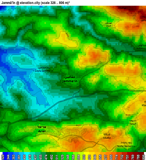
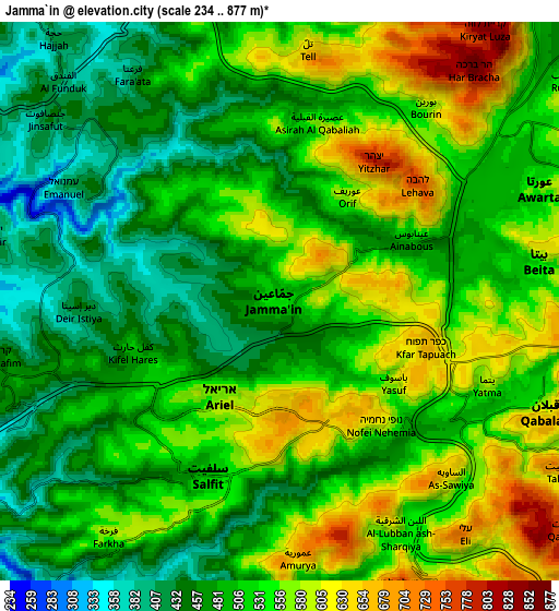
Below is the Elevation map of Jammā‘īn, which displays elevation range with different colors. Scale of the first map is from 326 to 806 m (1070 to 2644 ft) with average elevation of 526.5 meters (=1727 ft) [note 1]
These maps also provides idea of topography and contour of this city, they are displayed at different zoom levels. More info about maps, scale and edge coordinates you can find below images.
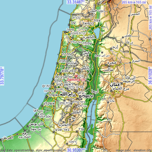
| \ | Map #1 | Map #2 | Topo.Map |
| Scale [m] | 326..806 m | 234..877 m | × |
| Scale [ft] | 1070..2644 ft | 768..2877 ft | × |
| Average | 526.5 m = 1727 ft | 519.6 m = 1705 ft | × |
| Width | 8.28 km = 5.1 mi | 16.55 km = 10.3 mi | 264.8 km = 164.5 mi |
| Height | 8.28 km = 5.1 mi | 16.55 km = 10.3 mi | 264.8 km = 164.5 mi |
| ↑Max Latitude | 32.168847° | 32.206038° | 33.31467° |
| Latitude at center | 32.13164° | 32.13164° | 32.13164° |
| ↓Min Latitude | 32.094418° | 32.057181° | 30.93307° |
| ← Min Longitude | 35.160085° | 35.116139° | 33.79778° |
| Longitude center | 35.20403° | 35.20403° | 35.20403° |
| →Max Longitude | 35.247975° | 35.291921° | 36.61028° |
Nearby cities:
Cities around Jammā‘īn sort by population:
• Salfīt elevation 510 m
5.8 km,  202°
202°
• Ḩuwwārah 522 m
5.5 km,  65°
65°
• Dayr Istiyā 445 m
6.1 km,  269°
269°
• Kifil Ḩāris 516 m
4.7 km,  251°
251°
• Ḩāris 479 m
6.2 km, 251°
• ‘Ūrīf 584 m
3.5 km,  29°
29°
• ‘Aşīrah al Qiblīyah 579 m
5.3 km,  11°
11°
• ‘Aynabūs 506 m
4.2 km, 66°
• Mardā 442 m
2.1 km, 202°
• Zaytā Jammā‘īn 447 m
1.8 km,  289°
289°
• Yāsūf 580 m
4.1 km,  129°
129°
• Qīrah 489 m
3.2 km, 250°
Multilingual:
 En español:
Jammā‘īn elevación 531 m.
 En France:
Jammā‘īn élévation 531 m.
 Auf Deutsch:
Jammā‘īn höhe über dem Meeresspiegel ist 531 m.

Sources and notes:
- [note 1] Map square and city borders are not equal. Map elevation data is calculated only from area inside that square.
- [src 1] Elevation data from geonames database provided with same terms of usage.
- [src 2] The elevation map of Jammā‘īn is generated using elevation data from NASA's 3 arcsec (90m) resolution SRTM data.
- [src 3] Base (background) map © OpenStreetMap contributors tiles are generated by Geofabrik and OpenTopoMap.
Copyright & License:
This Jammā‘īn Elevation Map is licensed under CC BY-SA. You may reuse any part from this page, if you give a proper credit by linking to this URL:
 More info on terms of use page.