Salfīt elevation
Salfīt (West Bank, Salfit), Palestinian Territory elevation is 510 meters and Salfīt elevation in feet is 1673 ft above sea level [src 1]. Salfīt is a populated place (feature code) with elevation that is 43 meters (141 ft) bigger than average city elevation in Palestinian Territory.
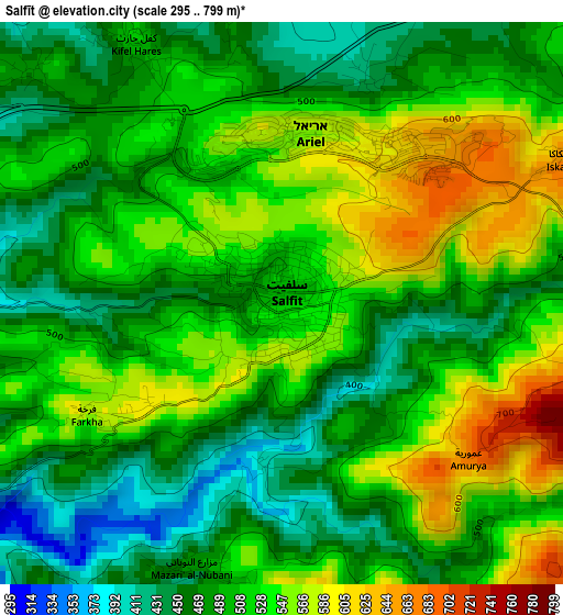
Below is the Elevation map of Salfīt, which displays elevation range with different colors. Scale of the first map is from 295 to 799 m (968 to 2621 ft) with average elevation of 510.1 meters (=1674 ft) [note 1]
These maps also provides idea of topography and contour of this city, they are displayed at different zoom levels. More info about maps, scale and edge coordinates you can find below images.

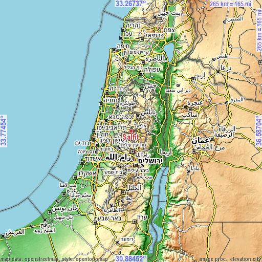
| \ | Map #1 | Map #2 | Topo.Map |
| Scale [m] | 295..799 m | 222..918 m | × |
| Scale [ft] | 968..2621 ft | 728..3012 ft | × |
| Average | 510.1 m = 1674 ft | 510.3 m = 1674 ft | × |
| Width | 8.28 km = 5.1 mi | 16.56 km = 10.3 mi | 264.9 km = 164.6 mi |
| Height | 8.28 km = 5.1 mi | 16.56 km = 10.3 mi | 265 km = 164.7 mi |
| ↑Max Latitude | 32.120936° | 32.158147° | 33.26737° |
| Latitude at center | 32.08371° | 32.08371° | 32.08371° |
| ↓Min Latitude | 32.046469° | 32.009212° | 30.88452° |
| ← Min Longitude | 35.136845° | 35.092899° | 33.77454° |
| Longitude center | 35.18079° | 35.18079° | 35.18079° |
| →Max Longitude | 35.224735° | 35.268681° | 36.58704° |
Nearby cities:
Cities around Salfīt sort by population:
• Jammā‘īn elevation 531 m
5.8 km,  22°
22°
• Banī Zayd ash Shārqīyah 478 m
4.1 km,  200°
200°
• Kifil Ḩāris 516 m
4.4 km,  329°
329°
• ‘Ibwayn 674 m
6.1 km,  162°
162°
• Ḩāris 479 m
5 km,  312°
312°
• Qarāwat Banī Zayd 345 m
5.8 km,  236°
236°
• Al Lubban ash Sharqīyah 586 m
5.8 km,  105°
105°
• Mardā 442 m
3.6 km, 22°
• Zaytā Jammā‘īn 447 m
5.9 km,  4°
4°
• Yāsūf 580 m
6 km,  62°
62°
• Farkhah 586 m
3.1 km, 237°
• Qīrah 489 m
4.4 km,  348°
348°
Multilingual:
 En español:
Salfīt elevación 510 m.
 En France:
Salfīt élévation 510 m.


Sources and notes:
- [note 1] Map square and city borders are not equal. Map elevation data is calculated only from area inside that square.
- [src 1] Elevation data from geonames database provided with same terms of usage.
- [src 2] The elevation map of Salfīt is generated using elevation data from NASA's 3 arcsec (90m) resolution SRTM data.
- [src 3] Base (background) map © OpenStreetMap contributors tiles are generated by Geofabrik and OpenTopoMap.
Copyright & License:
This Salfīt Elevation Map is licensed under CC BY-SA. You may reuse any part from this page, if you give a proper credit by linking to this URL:
 More info on terms of use page.