Oranit elevation
Oranit (West Bank), Palestinian Territory elevation is 128 meters and Oranit elevation in feet is 420 ft above sea level [src 1]. Oranit is a populated place (feature code) with elevation that is 339 meters (1112 ft) smaller than average city elevation in Palestinian Territory.
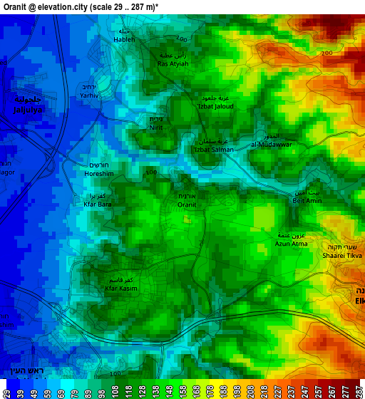
Below is the Elevation map of Oranit, which displays elevation range with different colors. Scale of the first map is from 29 to 287 m (95 to 942 ft) with average elevation of 113.8 meters (=373 ft) [note 1]
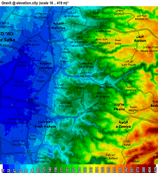
These maps also provides idea of topography and contour of this city, they are displayed at different zoom levels. More info about maps, scale and edge coordinates you can find below images.
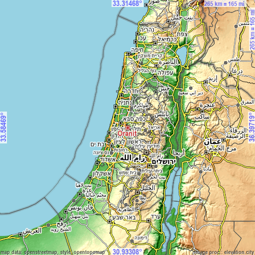
| \ | Map #1 | Map #2 | Topo.Map |
| Scale [m] | 29..287 m | 16..419 m | × |
| Scale [ft] | 95..942 ft | 52..1375 ft | × |
| Average | 113.8 m = 373 ft | 138.8 m = 455 ft | × |
| Width | 8.28 km = 5.1 mi | 16.55 km = 10.3 mi | 264.8 km = 164.5 mi |
| Height | 8.28 km = 5.1 mi | 16.55 km = 10.3 mi | 264.8 km = 164.5 mi |
| ↑Max Latitude | 32.168857° | 32.206048° | 33.31468° |
| Latitude at center | 32.13165° | 32.13165° | 32.13165° |
| ↓Min Latitude | 32.094428° | 32.057191° | 30.93308° |
| ← Min Longitude | 34.946995° | 34.903049° | 33.58469° |
| Longitude center | 34.99094° | 34.99094° | 34.99094° |
| →Max Longitude | 35.034885° | 35.078831° | 36.39719° |
Nearby cities:
Cities around Oranit sort by population:
• Qalqīlyah elevation 87 m
6.7 km,  343°
343°
• Bidyā 344 m
8.6 km,  102°
102°
• ‘Azzūn 253 m
7.9 km,  52°
52°
• Ḩablah 90 m
3.9 km, 341°
• Az Zāwiyah 250 m
6.1 km,  130°
130°
• Kafr Thulth 281 m
5.8 km,  65°
65°
• Dayr Ballūţ 284 m
8 km,  156°
156°
• Sannīryā 245 m
5.2 km,  93°
93°
• Masḩah 293 m
6.2 km,  114°
114°
• Rāfāt 306 m
7.8 km,  139°
139°
• Azun Atme 165 m
3 km, 111°
• An Nabī Ilyās 170 m
6.4 km,  23°
23°
Multilingual:
 En español:
Oranit elevación 128 m.
 En France:
Oranit élévation 128 m.


Sources and notes:
- [note 1] Map square and city borders are not equal. Map elevation data is calculated only from area inside that square.
- [src 1] Elevation data from geonames database provided with same terms of usage.
- [src 2] The elevation map of Oranit is generated using elevation data from NASA's 3 arcsec (90m) resolution SRTM data.
- [src 3] Base (background) map © OpenStreetMap contributors tiles are generated by Geofabrik and OpenTopoMap.
Copyright & License:
This Oranit Elevation Map is licensed under CC BY-SA. You may reuse any part from this page, if you give a proper credit by linking to this URL:
 More info on terms of use page.