Punta Santiago elevation
Punta Santiago (Humacao, Punta Santiago Barrio), Puerto Rico elevation is 4 meters and Punta Santiago elevation in feet is 13 ft above sea level [src 1]. Punta Santiago is a populated place (feature code) with elevation that is 96 meters (315 ft) smaller than average city elevation in Puerto Rico.
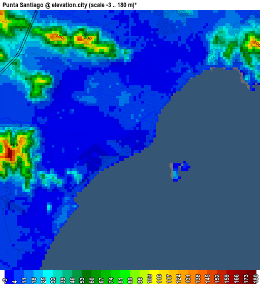
Below is the Elevation map of Punta Santiago, which displays elevation range with different colors. Scale of the first map is from -3 to 180 m (-10 to 591 ft) with average elevation of 17.8 meters (=58 ft) [note 1]
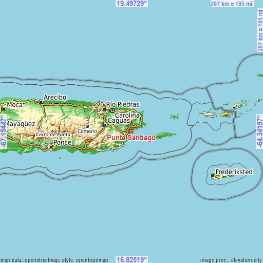
These maps also provides idea of topography and contour of this city, they are displayed at different zoom levels. More info about maps, scale and edge coordinates you can find below images.
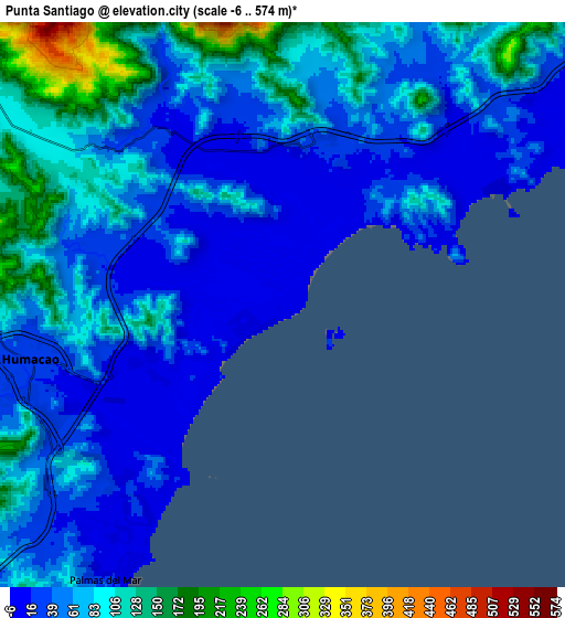
| \ | Map #1 | Map #2 | Topo.Map |
| Scale [m] | -3..180 m | -6..574 m | × |
| Scale [ft] | -10..591 ft | -20..1883 ft | × |
| Average | 17.8 m = 58 ft | 68.1 m = 223 ft | × |
| Width | 9.29 km = 5.8 mi | 18.57 km = 11.5 mi | 297.1 km = 184.6 mi |
| Height | 9.29 km = 5.8 mi | 18.57 km = 11.5 mi | 297.1 km = 184.6 mi |
| ↑Max Latitude | 18.2081° | 18.24984° | 19.49729° |
| Latitude at center | 18.16635° | 18.16635° | 18.16635° |
| ↓Min Latitude | 18.12459° | 18.08282° | 16.82519° |
| ← Min Longitude | -65.792165° | -65.836111° | -67.15447° |
| Longitude center | -65.74822° | -65.74822° | -65.74822° |
| →Max Longitude | -65.704275° | -65.660329° | -64.34197° |
Nearby cities:
Cities around Punta Santiago sort by population:
• Humacao elevation 25 m
8.6 km,  257°
257°
• Las Piedras 136 m
12.6 km,  278°
278°
• Naguabo 20 m
5.2 km,  15°
15°
• La Fermina 130 m
11.2 km, 275°
• Antón Ruiz 31 m
6.7 km,  288°
288°
• Duque 75 m
7.9 km,  5°
5°
• Daguao 35 m
9.6 km,  45°
45°
• Bajandas 38 m
3.6 km,  254°
254°
• Río Blanco 17 m
7.2 km,  323°
323°
• Candelero Arriba 73 m
11.8 km,  232°
232°
• Boqueron 102 m
11.5 km, 293°
• Peña Pobre 103 m
9.5 km,  305°
305°
Multilingual:
 En español:
Punta Santiago elevación 4 m.
 En France:
Punta Santiago élévation 4 m.
 Auf Deutsch:
Punta Santiago höhe über dem Meeresspiegel ist 4 m.

Sources and notes:
- [note 1] Map square and city borders are not equal. Map elevation data is calculated only from area inside that square.
- [src 1] Elevation data from geonames database provided with same terms of usage.
- [src 2] The elevation map of Punta Santiago is generated using elevation data from NASA's 3 arcsec (90m) resolution SRTM data.
- [src 3] Base (background) map © OpenStreetMap contributors tiles are generated by Geofabrik and OpenTopoMap.
Copyright & License:
This Punta Santiago Elevation Map is licensed under CC BY-SA. You may reuse any part from this page, if you give a proper credit by linking to this URL:
 More info on terms of use page.