Aibonito elevation
Aibonito, Puerto Rico elevation is 607 meters and Aibonito elevation in feet is 1991 ft above sea level [src 1]. Aibonito is a seat of a first-order administrative division (feature code) with elevation that is 507 meters (1663 ft) bigger than average city elevation in Puerto Rico.
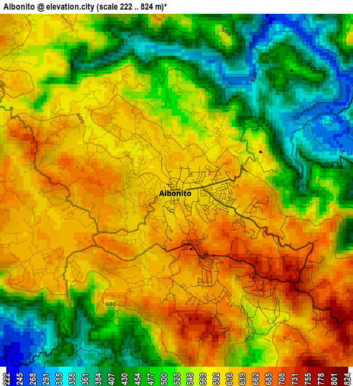
Below is the Elevation map of Aibonito, which displays elevation range with different colors. Scale of the first map is from 222 to 824 m (728 to 2703 ft) with average elevation of 551.3 meters (=1809 ft) [note 1]
These maps also provides idea of topography and contour of this city, they are displayed at different zoom levels. More info about maps, scale and edge coordinates you can find below images.
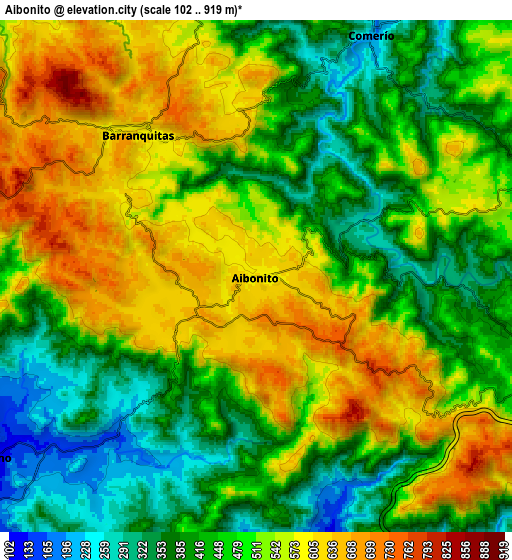
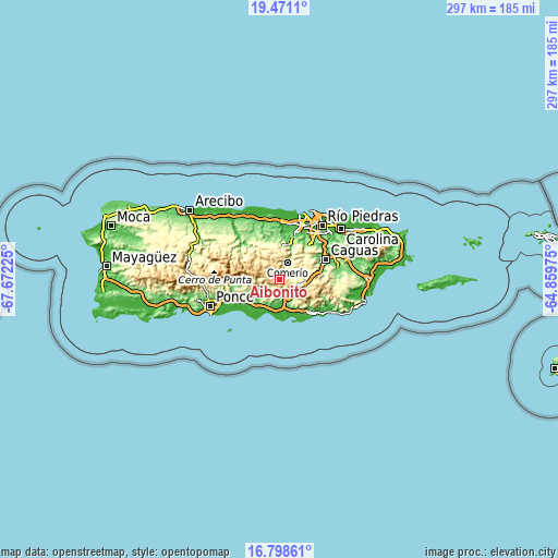
| \ | Map #1 | Map #2 | Topo.Map |
| Scale [m] | 222..824 m | 102..919 m | × |
| Scale [ft] | 728..2703 ft | 335..3015 ft | × |
| Average | 551.3 m = 1809 ft | 490.7 m = 1610 ft | × |
| Width | 9.29 km = 5.8 mi | 18.57 km = 11.5 mi | 297.2 km = 184.7 mi |
| Height | 9.29 km = 5.8 mi | 18.57 km = 11.5 mi | 297.2 km = 184.7 mi |
| ↑Max Latitude | 18.181716° | 18.223462° | 19.4711° |
| Latitude at center | 18.13996° | 18.13996° | 18.13996° |
| ↓Min Latitude | 18.098194° | 18.056418° | 16.79861° |
| ← Min Longitude | -66.309945° | -66.353891° | -67.67225° |
| Longitude center | -66.266° | -66.266° | -66.266° |
| →Max Longitude | -66.222055° | -66.178109° | -64.85975° |
Nearby cities:
Cities around Aibonito sort by population:
• Cayey elevation 397 m
11 km,  106°
106°
• Coamo 126 m
11.8 km,  235°
235°
• Cidra 426 m
11.8 km,  70°
70°
• Comerío 202 m
9.7 km,  25°
25°
• Barranquitas 603 m
6.7 km,  320°
320°
• Vázquez 157 m
8.7 km,  160°
160°
• Palomas 597 m
10.3 km,  5°
5°
• Parcelas Nuevas 424 m
9.9 km,  89°
89°
• Pastos 655 m
2.6 km, 162°
• Parcelas La Milagrosa 552 m
8.9 km, 67°
• Palmarejo 241 m
10.2 km,  218°
218°
• La Plena 183 m
12.2 km,  147°
147°
Multilingual:
 En español:
Aibonito elevación 607 m.
 En France:
Aibonito élévation 607 m.
 Auf Deutsch:
Aibonito höhe über dem Meeresspiegel ist 607 m.

Sources and notes:
- [note 1] Map square and city borders are not equal. Map elevation data is calculated only from area inside that square.
- [src 1] Elevation data from geonames database provided with same terms of usage.
- [src 2] The elevation map of Aibonito is generated using elevation data from NASA's 3 arcsec (90m) resolution SRTM data.
- [src 3] Base (background) map © OpenStreetMap contributors tiles are generated by Geofabrik and OpenTopoMap.
Copyright & License:
This Aibonito Elevation Map is licensed under CC BY-SA. You may reuse any part from this page, if you give a proper credit by linking to this URL:
 More info on terms of use page.