Brzeźnica elevation
Brzeźnica (Subcarpathian, Powiat dębicki), Poland elevation is 187 meters and Brzeźnica elevation in feet is 614 ft above sea level [src 1]. Brzeźnica is a populated place (feature code) with elevation that is 4 meters (13 ft) smaller than average city elevation in Poland.
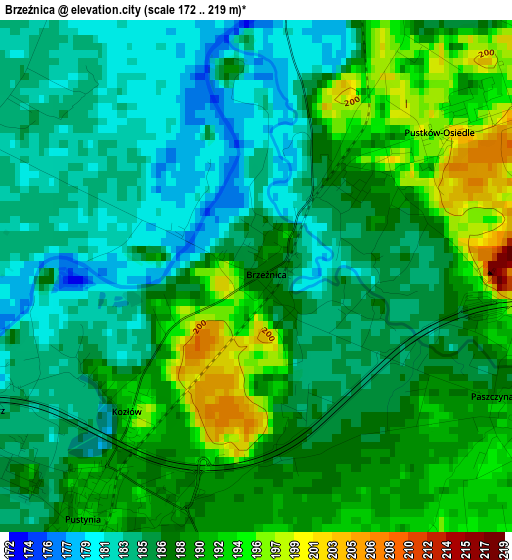
Below is the Elevation map of Brzeźnica, which displays elevation range with different colors. Scale of the first map is from 172 to 219 m (564 to 719 ft) with average elevation of 187.5 meters (=615 ft) [note 1]
These maps also provides idea of topography and contour of this city, they are displayed at different zoom levels. More info about maps, scale and edge coordinates you can find below images.
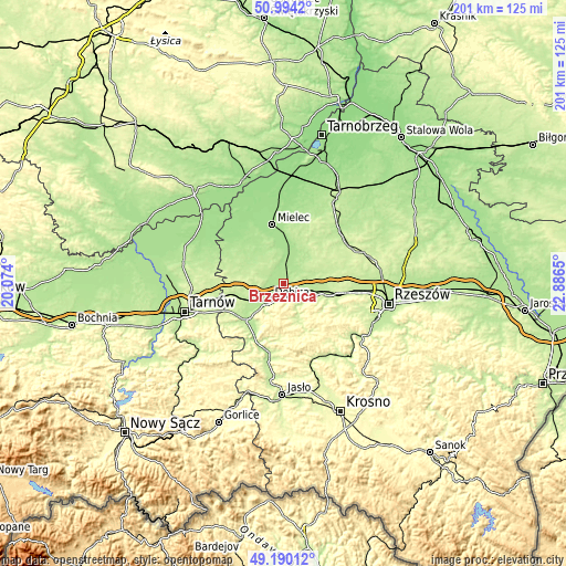
| \ | Map #1 | Topo.Map |
| Scale [m] | 172..219 m | × |
| Scale [ft] | 564..719 ft | × |
| Average | 187.5 m = 615 ft | × |
| Width | 6.27 km = 3.9 mi | 200.6 km = 124.6 mi |
| Height | 6.27 km = 3.9 mi | 200.6 km = 124.6 mi |
| ↑Max Latitude | 50.12883° | 50.9942° |
| Latitude at center | 50.10065° | 50.10065° |
| ↓Min Latitude | 50.072453° | 49.19012° |
| ← Min Longitude | 21.436305° | 20.074° |
| Longitude center | 21.48025° | 21.48025° |
| →Max Longitude | 21.524195° | 22.8865° |
Nearby cities:
Cities around Brzeźnica sort by population:
• Dębica elevation 200 m
7.4 km,  221°
221°
• Ropczyce 210 m
10.6 km,  120°
120°
• Sędziszów Małopolski 220 m
16.1 km,  101°
101°
• Pilzno 207 m
19.1 km, 224°
• Zagórzyce 234 m
16.7 km, 123°
• Radomyśl Wielki 197 m
18 km,  306°
306°
• Czarna 203 m
16.4 km,  256°
256°
• Niedźwiada 242 m
12.7 km,  166°
166°
• Przecław 189 m
10.3 km,  359°
359°
• Niwiska 223 m
17.5 km,  37°
37°
• Ostrów 195 m
8.1 km,  92°
92°
• Żyraków 187 m
6.2 km,  254°
254°
Multilingual:
 En español:
Brzeźnica elevación 187 m.
 En France:
Brzeźnica élévation 187 m.
 Auf Deutsch:
Brzeźnica höhe über dem Meeresspiegel ist 187 m.

Sources and notes:
- [note 1] Map square and city borders are not equal. Map elevation data is calculated only from area inside that square.
- [src 1] Elevation data from geonames database provided with same terms of usage.
- [src 2] The elevation map of Brzeźnica is generated using elevation data from NASA's 3 arcsec (90m) resolution SRTM data.
- [src 3] Base (background) map © OpenStreetMap contributors tiles are generated by Geofabrik and OpenTopoMap.
Copyright & License:
This Brzeźnica Elevation Map is licensed under CC BY-SA. You may reuse any part from this page, if you give a proper credit by linking to this URL:
 More info on terms of use page.