Ostrów elevation
Ostrów (Subcarpathian, Powiat ropczycko-sędziszowski), Poland elevation is 195 meters and Ostrów elevation in feet is 640 ft above sea level [src 1]. Ostrów is a seat of a third-order administrative division (feature code) with elevation that is 4 meters (13 ft) bigger than average city elevation in Poland.
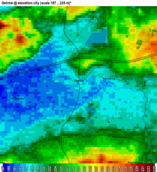
Below is the Elevation map of Ostrów, which displays elevation range with different colors. Scale of the first map is from 187 to 235 m (614 to 771 ft) with average elevation of 201.9 meters (=662 ft) [note 1]
These maps also provides idea of topography and contour of this city, they are displayed at different zoom levels. More info about maps, scale and edge coordinates you can find below images.
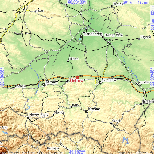
| \ | Map #1 | Topo.Map |
| Scale [m] | 187..235 m | × |
| Scale [ft] | 614..771 ft | × |
| Average | 201.9 m = 662 ft | × |
| Width | 6.27 km = 3.9 mi | 200.6 km = 124.6 mi |
| Height | 6.27 km = 3.9 mi | 200.6 km = 124.6 mi |
| ↑Max Latitude | 50.125972° | 50.99139° |
| Latitude at center | 50.09779° | 50.09779° |
| ↓Min Latitude | 50.069592° | 49.1872° |
| ← Min Longitude | 21.549255° | 20.18695° |
| Longitude center | 21.5932° | 21.5932° |
| →Max Longitude | 21.637145° | 22.99945° |
Nearby cities:
Cities around Ostrów sort by population:
• Dębica elevation 200 m
14 km,  248°
248°
• Ropczyce 210 m
5.2 km,  167°
167°
• Sędziszów Małopolski 220 m
8.2 km,  111°
111°
• Wielopole Skrzyńskie 256 m
17 km, 174°
• Zagórzyce 234 m
10.7 km,  146°
146°
• Brzeźnica 187 m
8.1 km,  272°
272°
• Niedźwiada 242 m
13.1 km,  202°
202°
• Trzciana 231 m
17.7 km,  99°
99°
• Przecław 189 m
13.3 km,  322°
322°
• Niwiska 223 m
14.4 km,  10°
10°
• Żyraków 187 m
14.1 km,  264°
264°
• Iwierzyce 237 m
13.8 km,  123°
123°
Multilingual:
 En español:
Ostrów elevación 195 m.
 En France:
Ostrów élévation 195 m.


Sources and notes:
- [note 1] Map square and city borders are not equal. Map elevation data is calculated only from area inside that square.
- [src 1] Elevation data from geonames database provided with same terms of usage.
- [src 2] The elevation map of Ostrów is generated using elevation data from NASA's 3 arcsec (90m) resolution SRTM data.
- [src 3] Base (background) map © OpenStreetMap contributors tiles are generated by Geofabrik and OpenTopoMap.
Copyright & License:
This Ostrów Elevation Map is licensed under CC BY-SA. You may reuse any part from this page, if you give a proper credit by linking to this URL:
 More info on terms of use page.