Niedźwiada elevation
Niedźwiada (Subcarpathian, Powiat ropczycko-sędziszowski), Poland elevation is 242 meters and Niedźwiada elevation in feet is 794 ft above sea level [src 1]. Niedźwiada is a populated place (feature code) with elevation that is 51 meters (167 ft) bigger than average city elevation in Poland.
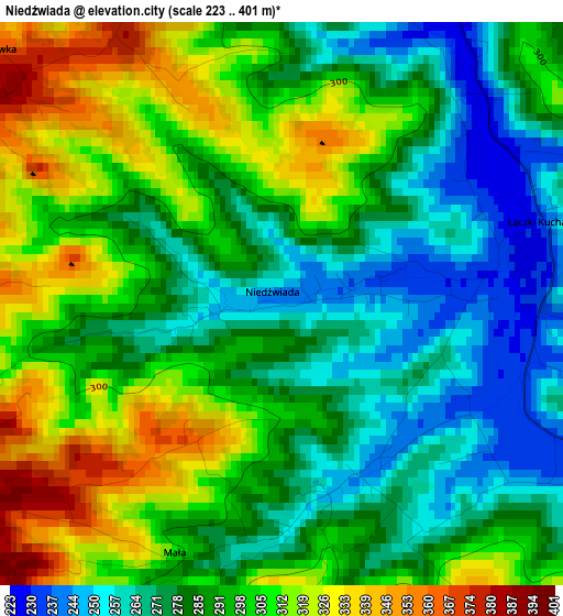
Below is the Elevation map of Niedźwiada, which displays elevation range with different colors. Scale of the first map is from 223 to 401 m (732 to 1316 ft) with average elevation of 291.6 meters (=957 ft) [note 1]
These maps also provides idea of topography and contour of this city, they are displayed at different zoom levels. More info about maps, scale and edge coordinates you can find below images.
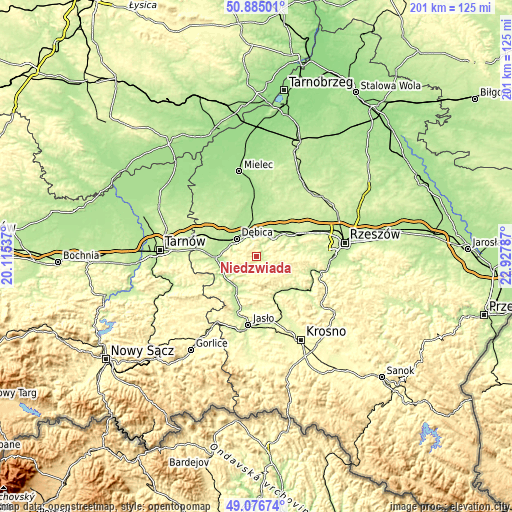
| \ | Map #1 | Topo.Map |
| Scale [m] | 223..401 m | × |
| Scale [ft] | 732..1316 ft | × |
| Average | 291.6 m = 957 ft | × |
| Width | 6.28 km = 3.9 mi | 201.1 km = 125 mi |
| Height | 6.28 km = 3.9 mi | 201 km = 124.9 mi |
| ↑Max Latitude | 50.017615° | 50.88501° |
| Latitude at center | 49.98937° | 49.98937° |
| ↓Min Latitude | 49.961108° | 49.07674° |
| ← Min Longitude | 21.477675° | 20.11537° |
| Longitude center | 21.52162° | 21.52162° |
| →Max Longitude | 21.565565° | 22.92787° |
Nearby cities:
Cities around Niedźwiada sort by population:
• Dębica elevation 200 m
10.5 km,  311°
311°
• Ropczyce 210 m
9.4 km,  41°
41°
• Sędziszów Małopolski 220 m
15.7 km,  54°
54°
• Pilzno 207 m
16.4 km,  265°
265°
• Wielopole Skrzyńskie 256 m
8.3 km,  126°
126°
• Zagórzyce 234 m
11.4 km,  74°
74°
• Brzeźnica 187 m
12.7 km,  346°
346°
• Brzostek 227 m
14.6 km,  212°
212°
• Wiśniowa 241 m
16.4 km,  144°
144°
• Ostrów 195 m
13.1 km,  22°
22°
• Żyraków 187 m
13.9 km,  320°
320°
• Słotowa 226 m
17 km,  253°
253°
Multilingual:
 En español:
Niedźwiada elevación 242 m.
 En France:
Niedźwiada élévation 242 m.
 Auf Deutsch:
Niedźwiada höhe über dem Meeresspiegel ist 242 m.

Sources and notes:
- [note 1] Map square and city borders are not equal. Map elevation data is calculated only from area inside that square.
- [src 1] Elevation data from geonames database provided with same terms of usage.
- [src 2] The elevation map of Niedźwiada is generated using elevation data from NASA's 3 arcsec (90m) resolution SRTM data.
- [src 3] Base (background) map © OpenStreetMap contributors tiles are generated by Geofabrik and OpenTopoMap.
Copyright & License:
This Niedźwiada Elevation Map is licensed under CC BY-SA. You may reuse any part from this page, if you give a proper credit by linking to this URL:
 More info on terms of use page.