Słotowa elevation
Słotowa (Subcarpathian, Powiat dębicki), Poland elevation is 226 meters and Słotowa elevation in feet is 741 ft above sea level [src 1]. Słotowa is a populated place (feature code) with elevation that is 35 meters (115 ft) bigger than average city elevation in Poland.
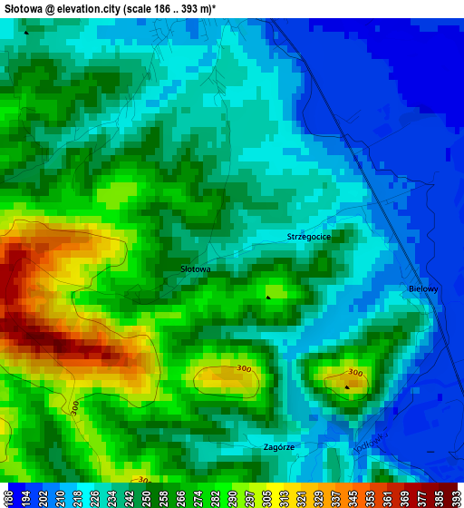
Below is the Elevation map of Słotowa, which displays elevation range with different colors. Scale of the first map is from 186 to 393 m (610 to 1289 ft) with average elevation of 245.5 meters (=805 ft) [note 1]
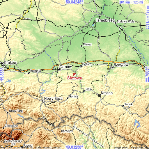
These maps also provides idea of topography and contour of this city, they are displayed at different zoom levels. More info about maps, scale and edge coordinates you can find below images.
| \ | Map #1 | Topo.Map |
| Scale [m] | 186..393 m | × |
| Scale [ft] | 610..1289 ft | × |
| Average | 245.5 m = 805 ft | × |
| Width | 6.29 km = 3.9 mi | 201.2 km = 125 mi |
| Height | 6.29 km = 3.9 mi | 201.2 km = 125 mi |
| ↑Max Latitude | 49.974301° | 50.84248° |
| Latitude at center | 49.94603° | 49.94603° |
| ↓Min Latitude | 49.917742° | 49.03258° |
| ← Min Longitude | 21.250305° | 19.888° |
| Longitude center | 21.29425° | 21.29425° |
| →Max Longitude | 21.338195° | 22.7005° |
Nearby cities:
Cities around Słotowa sort by population:
• Dębica elevation 200 m
14.4 km,  35°
35°
• Pilzno 207 m
3.6 km,  357°
357°
• Jodłowa 248 m
8.3 km,  187°
187°
• Szynwałd 250 m
12.5 km,  281°
281°
• Ryglice 241 m
13.5 km,  236°
236°
• Pogórska Wola 229 m
12.6 km,  309°
309°
• Brzostek 227 m
11.2 km,  131°
131°
• Czarna 203 m
13.7 km,  348°
348°
• Szerzyny 267 m
15.6 km, 192°
• Brzyska 231 m
15.4 km,  153°
153°
• Łęki Górne 243 m
9.1 km,  289°
289°
• Łęki Dolne 217 m
4.6 km, 312°
Multilingual:
 En español:
Słotowa elevación 226 m.
 En France:
Słotowa élévation 226 m.


Sources and notes:
- [note 1] Map square and city borders are not equal. Map elevation data is calculated only from area inside that square.
- [src 1] Elevation data from geonames database provided with same terms of usage.
- [src 2] The elevation map of Słotowa is generated using elevation data from NASA's 3 arcsec (90m) resolution SRTM data.
- [src 3] Base (background) map © OpenStreetMap contributors tiles are generated by Geofabrik and OpenTopoMap.
Copyright & License:
This Słotowa Elevation Map is licensed under CC BY-SA. You may reuse any part from this page, if you give a proper credit by linking to this URL:
 More info on terms of use page.