Radomyśl Wielki elevation
Radomyśl Wielki (Subcarpathian, Powiat mielecki), Poland elevation is 197 meters and Radomyśl Wielki elevation in feet is 646 ft above sea level [src 1]. Radomyśl Wielki is a populated place (feature code) with elevation that is 6 meters (20 ft) bigger than average city elevation in Poland.
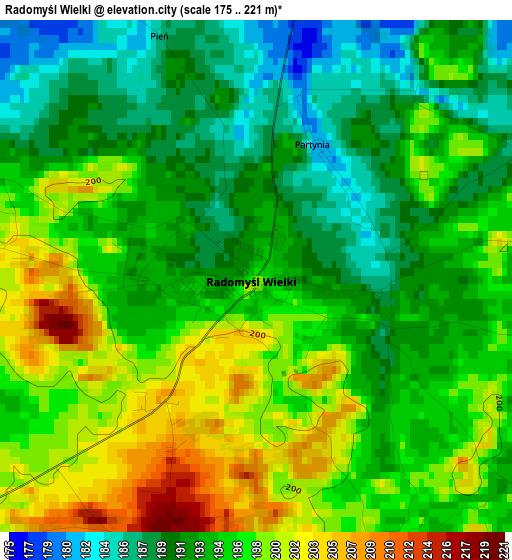
Below is the Elevation map of Radomyśl Wielki, which displays elevation range with different colors. Scale of the first map is from 175 to 221 m (574 to 725 ft) with average elevation of 194.7 meters (=639 ft) [note 1]
These maps also provides idea of topography and contour of this city, they are displayed at different zoom levels. More info about maps, scale and edge coordinates you can find below images.

| \ | Map #1 | Topo.Map |
| Scale [m] | 175..221 m | × |
| Scale [ft] | 574..725 ft | × |
| Average | 194.7 m = 639 ft | × |
| Width | 6.26 km = 3.9 mi | 200.2 km = 124.4 mi |
| Height | 6.26 km = 3.9 mi | 200.2 km = 124.4 mi |
| ↑Max Latitude | 50.225053° | 51.08867° |
| Latitude at center | 50.19693° | 50.19693° |
| ↓Min Latitude | 50.16879° | 49.28822° |
| ← Min Longitude | 21.232985° | 19.87068° |
| Longitude center | 21.27693° | 21.27693° |
| →Max Longitude | 21.320875° | 22.68318° |
Nearby cities:
Cities around Radomyśl Wielki sort by population:
• Mielec elevation 178 m
14.5 km,  46°
46°
• Dębica 200 m
18.8 km,  149°
149°
• Radgoszcz 181 m
11.7 km,  274°
274°
• Brzeźnica 187 m
18 km,  126°
126°
• Czarna 203 m
14.5 km,  185°
185°
• Przecław 189 m
14.5 km,  91°
91°
• Czermin 161 m
16.3 km,  14°
14°
• Żyraków 187 m
15 km, 145°
• Trzciana 163 m
13 km,  19°
19°
• Gruszów Wielki 190 m
17.5 km, 268°
• Słupiec 159 m
15.7 km,  337°
337°
• Wadowice Górne 182 m
7.6 km, 13°
Multilingual:
 En español:
Radomyśl Wielki elevación 197 m.
 En France:
Radomyśl Wielki élévation 197 m.
 Auf Deutsch:
Radomyśl Wielki höhe über dem Meeresspiegel ist 197 m.

Sources and notes:
- [note 1] Map square and city borders are not equal. Map elevation data is calculated only from area inside that square.
- [src 1] Elevation data from geonames database provided with same terms of usage.
- [src 2] The elevation map of Radomyśl Wielki is generated using elevation data from NASA's 3 arcsec (90m) resolution SRTM data.
- [src 3] Base (background) map © OpenStreetMap contributors tiles are generated by Geofabrik and OpenTopoMap.
Copyright & License:
This Radomyśl Wielki Elevation Map is licensed under CC BY-SA. You may reuse any part from this page, if you give a proper credit by linking to this URL:
 More info on terms of use page.