Gruszów Wielki elevation
Gruszów Wielki (Lesser Poland, Powiat dąbrowski), Poland elevation is 190 meters and Gruszów Wielki elevation in feet is 623 ft above sea level [src 1]. Gruszów Wielki is a populated place (feature code) with elevation that is 1 meters (3 ft) smaller than average city elevation in Poland.
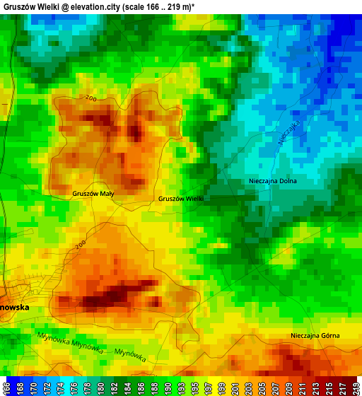
Below is the Elevation map of Gruszów Wielki, which displays elevation range with different colors. Scale of the first map is from 166 to 219 m (545 to 719 ft) with average elevation of 191.3 meters (=628 ft) [note 1]
These maps also provides idea of topography and contour of this city, they are displayed at different zoom levels. More info about maps, scale and edge coordinates you can find below images.
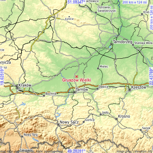
| \ | Map #1 | Topo.Map |
| Scale [m] | 166..219 m | × |
| Scale [ft] | 545..719 ft | × |
| Average | 191.3 m = 628 ft | × |
| Width | 6.26 km = 3.9 mi | 200.2 km = 124.4 mi |
| Height | 6.26 km = 3.9 mi | 200.2 km = 124.4 mi |
| ↑Max Latitude | 50.219756° | 51.08347° |
| Latitude at center | 50.19163° | 50.19163° |
| ↓Min Latitude | 50.163487° | 49.28281° |
| ← Min Longitude | 20.987495° | 19.62519° |
| Longitude center | 21.03144° | 21.03144° |
| →Max Longitude | 21.075385° | 22.43769° |
Nearby cities:
Cities around Gruszów Wielki sort by population:
• Dąbrowa Tarnowska elevation 208 m
3.7 km,  239°
239°
• Żabno 186 m
12.2 km, 237°
• Szczucin 165 m
13.5 km,  13°
13°
• Radgoszcz 181 m
6 km,  74°
74°
• Lisia Góra 244 m
12.4 km,  175°
175°
• Niedomice 184 m
13.5 km,  225°
225°
• Olesno 176 m
7.6 km,  278°
278°
• Smęgorzów 168 m
4.5 km,  334°
334°
• Mędrzechów 168 m
11.7 km, 329°
• Łukowa 244 m
11.7 km,  199°
199°
• Sieradza 190 m
9.6 km, 229°
• Biskupice Radłowskie 181 m
14.6 km, 237°
Multilingual:
 En español:
Gruszów Wielki elevación 190 m.
 En France:
Gruszów Wielki élévation 190 m.
 Auf Deutsch:
Gruszów Wielki höhe über dem Meeresspiegel ist 190 m.

Sources and notes:
- [note 1] Map square and city borders are not equal. Map elevation data is calculated only from area inside that square.
- [src 1] Elevation data from geonames database provided with same terms of usage.
- [src 2] The elevation map of Gruszów Wielki is generated using elevation data from NASA's 3 arcsec (90m) resolution SRTM data.
- [src 3] Base (background) map © OpenStreetMap contributors tiles are generated by Geofabrik and OpenTopoMap.
Copyright & License:
This Gruszów Wielki Elevation Map is licensed under CC BY-SA. You may reuse any part from this page, if you give a proper credit by linking to this URL:
 More info on terms of use page.