Chełm elevation
Chełm (Lublin), Poland elevation is 177 meters and Chełm elevation in feet is 581 ft above sea level [src 1]. Chełm is a populated place (feature code) with elevation that is 14 meters (46 ft) smaller than average city elevation in Poland.
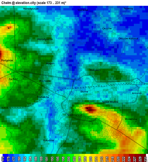
Below is the Elevation map of Chełm, which displays elevation range with different colors. Scale of the first map is from 173 to 231 m (568 to 758 ft) with average elevation of 188.5 meters (=618 ft) [note 1]
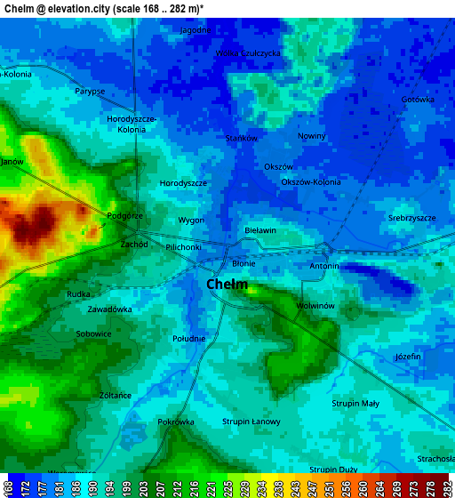
These maps also provides idea of topography and contour of this city, they are displayed at different zoom levels. More info about maps, scale and edge coordinates you can find below images.
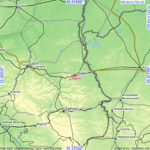
| \ | Map #1 | Map #2 | Topo.Map |
| Scale [m] | 173..231 m | 168..282 m | × |
| Scale [ft] | 568..758 ft | 551..925 ft | × |
| Average | 188.5 m = 618 ft | 191.4 m = 628 ft | × |
| Width | 6.13 km = 3.8 mi | 12.26 km = 7.6 mi | 196.2 km = 121.9 mi |
| Height | 6.13 km = 3.8 mi | 12.26 km = 7.6 mi | 196.2 km = 121.9 mi |
| ↑Max Latitude | 51.170682° | 51.198228° | 52.01696° |
| Latitude at center | 51.14312° | 51.14312° | 51.14312° |
| ↓Min Latitude | 51.115541° | 51.087946° | 50.25242° |
| ← Min Longitude | 23.427655° | 23.383709° | 22.06535° |
| Longitude center | 23.4716° | 23.4716° | 23.4716° |
| →Max Longitude | 23.515545° | 23.559491° | 24.87785° |
Nearby cities:
Cities around Chełm sort by population:
• Krasnystaw elevation 184 m
27.2 km,  229°
229°
• Rejowiec Fabryczny 200 m
16 km,  258°
258°
• Sawin 179 m
14.8 km,  349°
349°
• Rejowiec 199 m
14.4 km,  246°
246°
• Wola Uhruska 174 m
22.6 km,  28°
28°
• Wojsławice 218 m
25.4 km,  168°
168°
• Pokrówka 198 m
5.4 km,  186°
186°
• Cyców 171 m
28.8 km,  307°
307°
• Ruda-Huta 172 m
13.5 km,  39°
39°
• Siennica Różana 194 m
18.9 km,  213°
213°
• Dorohusk 174 m
23.2 km,  86°
86°
• Kraśniczyn 199 m
25 km,  199°
199°
Multilingual:
 En español:
Chełm elevación 177 m.
 En France:
Chełm élévation 177 m.


Sources and notes:
- [note 1] Map square and city borders are not equal. Map elevation data is calculated only from area inside that square.
- [src 1] Elevation data from geonames database provided with same terms of usage.
- [src 2] The elevation map of Chełm is generated using elevation data from NASA's 3 arcsec (90m) resolution SRTM data.
- [src 3] Base (background) map © OpenStreetMap contributors tiles are generated by Geofabrik and OpenTopoMap.
Copyright & License:
This Chełm Elevation Map is licensed under CC BY-SA. You may reuse any part from this page, if you give a proper credit by linking to this URL:
 More info on terms of use page.