Wojsławice elevation
Wojsławice (Lublin, Powiat chełmski), Poland elevation is 218 meters and Wojsławice elevation in feet is 715 ft above sea level [src 1]. Wojsławice is a populated place (feature code) with elevation that is 27 meters (89 ft) bigger than average city elevation in Poland.
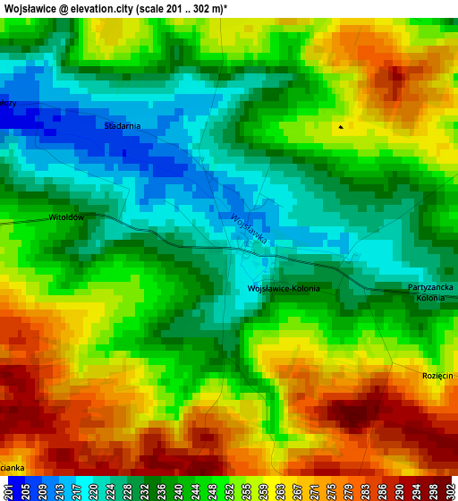
Below is the Elevation map of Wojsławice, which displays elevation range with different colors. Scale of the first map is from 201 to 302 m (659 to 991 ft) with average elevation of 247.8 meters (=813 ft) [note 1]
These maps also provides idea of topography and contour of this city, they are displayed at different zoom levels. More info about maps, scale and edge coordinates you can find below images.
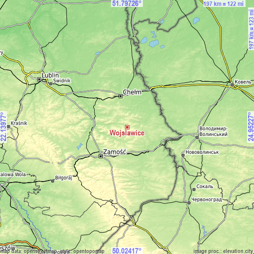
| \ | Map #1 | Topo.Map |
| Scale [m] | 201..302 m | × |
| Scale [ft] | 659..991 ft | × |
| Average | 247.8 m = 813 ft | × |
| Width | 6.16 km = 3.8 mi | 197.1 km = 122.5 mi |
| Height | 6.16 km = 3.8 mi | 197.1 km = 122.5 mi |
| ↑Max Latitude | 50.946856° | 51.79726° |
| Latitude at center | 50.91916° | 50.91916° |
| ↓Min Latitude | 50.891448° | 50.02417° |
| ← Min Longitude | 23.502075° | 22.13977° |
| Longitude center | 23.54602° | 23.54602° |
| →Max Longitude | 23.589965° | 24.95227° |
Nearby cities:
Cities around Wojsławice sort by population:
• Chełm elevation 177 m
25.4 km,  348°
348°
• Krasnystaw 184 m
27 km,  285°
285°
• Hrubieszów 188 m
27.4 km,  117°
117°
• Werbkowice 193 m
23.9 km,  140°
140°
• Rejowiec 199 m
26.6 km,  316°
316°
• Pokrówka 198 m
20.4 km,  343°
343°
• Skierbieszów 201 m
15.1 km,  240°
240°
• Siennica Różana 194 m
18.1 km,  300°
300°
• Grabowiec 215 m
10.9 km,  178°
178°
• Miączyn 222 m
20.4 km,  188°
188°
• Sitno 213 m
22.8 km,  214°
214°
• Kraśniczyn 199 m
13.9 km,  275°
275°
Multilingual:
 En español:
Wojsławice elevación 218 m.
 En France:
Wojsławice élévation 218 m.
 Auf Deutsch:
Wojsławice höhe über dem Meeresspiegel ist 218 m.

Sources and notes:
- [note 1] Map square and city borders are not equal. Map elevation data is calculated only from area inside that square.
- [src 1] Elevation data from geonames database provided with same terms of usage.
- [src 2] The elevation map of Wojsławice is generated using elevation data from NASA's 3 arcsec (90m) resolution SRTM data.
- [src 3] Base (background) map © OpenStreetMap contributors tiles are generated by Geofabrik and OpenTopoMap.
Copyright & License:
This Wojsławice Elevation Map is licensed under CC BY-SA. You may reuse any part from this page, if you give a proper credit by linking to this URL:
 More info on terms of use page.