Krasnystaw elevation
Krasnystaw (Lublin, Powiat krasnostawski), Poland elevation is 184 meters and Krasnystaw elevation in feet is 604 ft above sea level [src 1]. Krasnystaw is a seat of a second-order administrative division (feature code) with elevation that is 7 meters (23 ft) smaller than average city elevation in Poland.
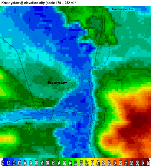
Below is the Elevation map of Krasnystaw, which displays elevation range with different colors. Scale of the first map is from 170 to 252 m (558 to 827 ft) with average elevation of 194.3 meters (=637 ft) [note 1]
These maps also provides idea of topography and contour of this city, they are displayed at different zoom levels. More info about maps, scale and edge coordinates you can find below images.
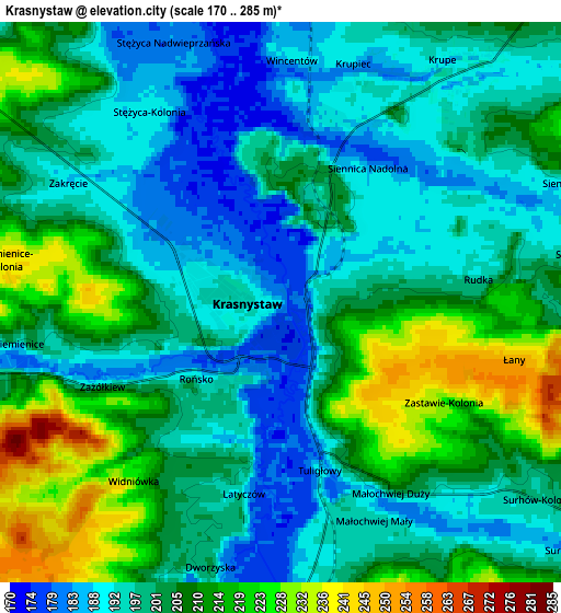
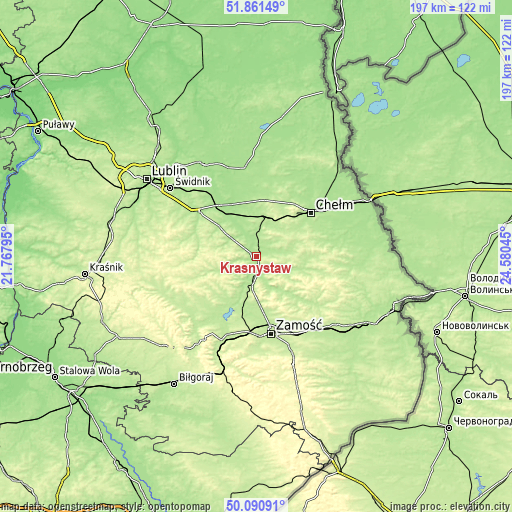
| \ | Map #1 | Map #2 | Topo.Map |
| Scale [m] | 170..252 m | 170..285 m | × |
| Scale [ft] | 558..827 ft | 558..935 ft | × |
| Average | 194.3 m = 637 ft | 202.2 m = 663 ft | × |
| Width | 6.15 km = 3.8 mi | 12.3 km = 7.6 mi | 196.9 km = 122.3 mi |
| Height | 6.15 km = 3.8 mi | 12.3 km = 7.6 mi | 196.9 km = 122.3 mi |
| ↑Max Latitude | 51.012297° | 51.039937° | 51.86149° |
| Latitude at center | 50.98464° | 50.98464° | 50.98464° |
| ↓Min Latitude | 50.956967° | 50.929277° | 50.09091° |
| ← Min Longitude | 23.130255° | 23.086309° | 21.76795° |
| Longitude center | 23.1742° | 23.1742° | 23.1742° |
| →Max Longitude | 23.218145° | 23.262091° | 24.58045° |
Nearby cities:
Cities around Krasnystaw sort by population:
• Rejowiec Fabryczny elevation 200 m
15.3 km,  19°
19°
• Trawniki 175 m
20.9 km,  323°
323°
• Rejowiec 199 m
14.1 km,  32°
32°
• Izbica 186 m
10.9 km,  188°
188°
• Fajsławice 188 m
19.3 km,  309°
309°
• Skierbieszów 201 m
19.7 km,  138°
138°
• Siennica Różana 194 m
10.5 km,  79°
79°
• Stary Zamość 204 m
18.3 km,  180°
180°
• Łopiennik Górny 193 m
12.6 km,  299°
299°
• Rudnik 228 m
18.3 km,  230°
230°
• Kraśniczyn 199 m
13.6 km,  115°
115°
• Gorzków 203 m
12 km,  250°
250°
Multilingual:
 En español:
Krasnystaw elevación 184 m.
 En France:
Krasnystaw élévation 184 m.
 Auf Deutsch:
Krasnystaw höhe über dem Meeresspiegel ist 184 m.

Sources and notes:
- [note 1] Map square and city borders are not equal. Map elevation data is calculated only from area inside that square.
- [src 1] Elevation data from geonames database provided with same terms of usage.
- [src 2] The elevation map of Krasnystaw is generated using elevation data from NASA's 3 arcsec (90m) resolution SRTM data.
- [src 3] Base (background) map © OpenStreetMap contributors tiles are generated by Geofabrik and OpenTopoMap.
Copyright & License:
This Krasnystaw Elevation Map is licensed under CC BY-SA. You may reuse any part from this page, if you give a proper credit by linking to this URL:
 More info on terms of use page.