Dorohusk elevation
Dorohusk (Lublin, Powiat chełmski), Poland elevation is 174 meters and Dorohusk elevation in feet is 571 ft above sea level [src 1]. Dorohusk is a seat of a third-order administrative division (feature code) with elevation that is 17 meters (56 ft) smaller than average city elevation in Poland.
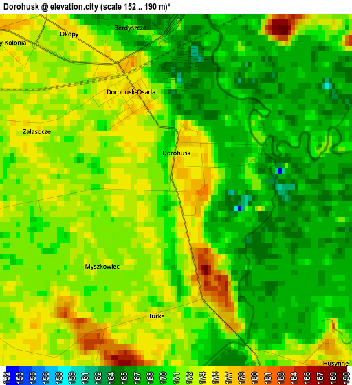
Below is the Elevation map of Dorohusk, which displays elevation range with different colors. Scale of the first map is from 152 to 190 m (499 to 623 ft) with average elevation of 171 meters (=561 ft) [note 1]
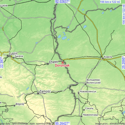
These maps also provides idea of topography and contour of this city, they are displayed at different zoom levels. More info about maps, scale and edge coordinates you can find below images.
| \ | Map #1 | Topo.Map |
| Scale [m] | 152..190 m | × |
| Scale [ft] | 499..623 ft | × |
| Average | 171 m = 561 ft | × |
| Width | 6.13 km = 3.8 mi | 196.1 km = 121.9 mi |
| Height | 6.13 km = 3.8 mi | 196.1 km = 121.9 mi |
| ↑Max Latitude | 51.182305° | 52.02837° |
| Latitude at center | 51.15475° | 51.15475° |
| ↓Min Latitude | 51.127178° | 50.26427° |
| ← Min Longitude | 23.759305° | 22.397° |
| Longitude center | 23.80325° | 23.80325° |
| →Max Longitude | 23.847195° | 25.2095° |
Nearby cities:
Cities around Dorohusk sort by population:
• Chełm elevation 177 m
23.2 km,  266°
266°
• Hrubieszów 188 m
39.4 km,  170°
170°
• Rejowiec Fabryczny 200 m
39.1 km,  263°
263°
• Sawin 179 m
29 km,  297°
297°
• Rejowiec 199 m
37.1 km, 259°
• Wola Uhruska 174 m
22.3 km,  326°
326°
• Wojsławice 218 m
31.8 km,  214°
214°
• Pokrówka 198 m
24.6 km,  254°
254°
• Horodło 189 m
33.2 km,  150°
150°
• Ruda-Huta 172 m
17.1 km, 302°
• Dubienka 179 m
13.3 km, 152°
• Siennica Różana 194 m
37.7 km,  243°
243°
Multilingual:
 En español:
Dorohusk elevación 174 m.
 En France:
Dorohusk élévation 174 m.
 Auf Deutsch:
Dorohusk höhe über dem Meeresspiegel ist 174 m.

Sources and notes:
- [note 1] Map square and city borders are not equal. Map elevation data is calculated only from area inside that square.
- [src 1] Elevation data from geonames database provided with same terms of usage.
- [src 2] The elevation map of Dorohusk is generated using elevation data from NASA's 3 arcsec (90m) resolution SRTM data.
- [src 3] Base (background) map © OpenStreetMap contributors tiles are generated by Geofabrik and OpenTopoMap.
Copyright & License:
This Dorohusk Elevation Map is licensed under CC BY-SA. You may reuse any part from this page, if you give a proper credit by linking to this URL:
 More info on terms of use page.