Kraśnik elevation
Kraśnik (Lublin, Powiat kraśnicki), Poland elevation is 199 meters and Kraśnik elevation in feet is 653 ft above sea level [src 1]. Kraśnik is a seat of a second-order administrative division (feature code) with elevation that is 8 meters (26 ft) bigger than average city elevation in Poland.
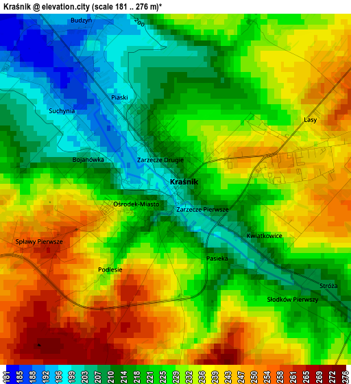
Below is the Elevation map of Kraśnik, which displays elevation range with different colors. Scale of the first map is from 181 to 276 m (594 to 906 ft) with average elevation of 227.1 meters (=745 ft) [note 1]
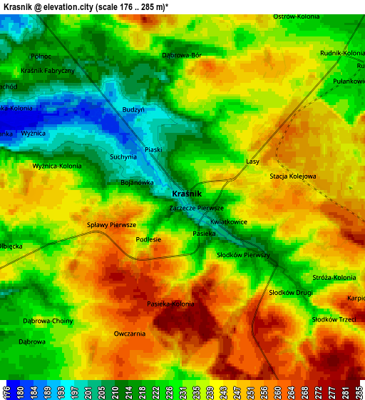
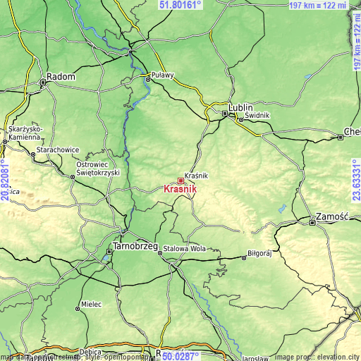
These maps also provides idea of topography and contour of this city, they are displayed at different zoom levels. More info about maps, scale and edge coordinates you can find below images.
| \ | Map #1 | Map #2 | Topo.Map |
| Scale [m] | 181..276 m | 176..285 m | × |
| Scale [ft] | 594..906 ft | 577..935 ft | × |
| Average | 227.1 m = 745 ft | 234.9 m = 771 ft | × |
| Width | 6.16 km = 3.8 mi | 12.32 km = 7.7 mi | 197.1 km = 122.5 mi |
| Height | 6.16 km = 3.8 mi | 12.32 km = 7.7 mi | 197.1 km = 122.5 mi |
| ↑Max Latitude | 50.951293° | 50.978969° | 51.80161° |
| Latitude at center | 50.9236° | 50.9236° | 50.9236° |
| ↓Min Latitude | 50.895891° | 50.868165° | 50.0287° |
| ← Min Longitude | 22.183115° | 22.139169° | 20.82081° |
| Longitude center | 22.22706° | 22.22706° | 22.22706° |
| →Max Longitude | 22.271005° | 22.314951° | 23.63331° |
Nearby cities:
Cities around Kraśnik sort by population:
• Wilkołaz elevation 225 m
13.3 km,  40°
40°
• Zakrzówek 214 m
11.2 km,  74°
74°
• Księżomierz 202 m
16.7 km,  264°
264°
• Sułów 235 m
9.6 km,  101°
101°
• Zdziechowice Drugie 187 m
17.5 km,  208°
208°
• Szastarka 278 m
10 km,  139°
139°
• Gościeradów 174 m
16.7 km,  248°
248°
• Urzędów 184 m
9.7 km,  322°
322°
• Potok Wielki 207 m
14.7 km,  182°
182°
• Trzydnik Duży 210 m
10.6 km,  218°
218°
• Borzechów 200 m
19.2 km,  11°
11°
• Dzierzkowice 176 m
12 km,  289°
289°
Multilingual:
 En español:
Kraśnik elevación 199 m.
 En France:
Kraśnik élévation 199 m.


Sources and notes:
- [note 1] Map square and city borders are not equal. Map elevation data is calculated only from area inside that square.
- [src 1] Elevation data from geonames database provided with same terms of usage.
- [src 2] The elevation map of Kraśnik is generated using elevation data from NASA's 3 arcsec (90m) resolution SRTM data.
- [src 3] Base (background) map © OpenStreetMap contributors tiles are generated by Geofabrik and OpenTopoMap.
Copyright & License:
This Kraśnik Elevation Map is licensed under CC BY-SA. You may reuse any part from this page, if you give a proper credit by linking to this URL:
 More info on terms of use page.