Księżomierz elevation
Księżomierz (Lublin, Powiat kraśnicki), Poland elevation is 202 meters and Księżomierz elevation in feet is 663 ft above sea level [src 1]. Księżomierz is a populated place (feature code) with elevation that is 11 meters (36 ft) bigger than average city elevation in Poland.
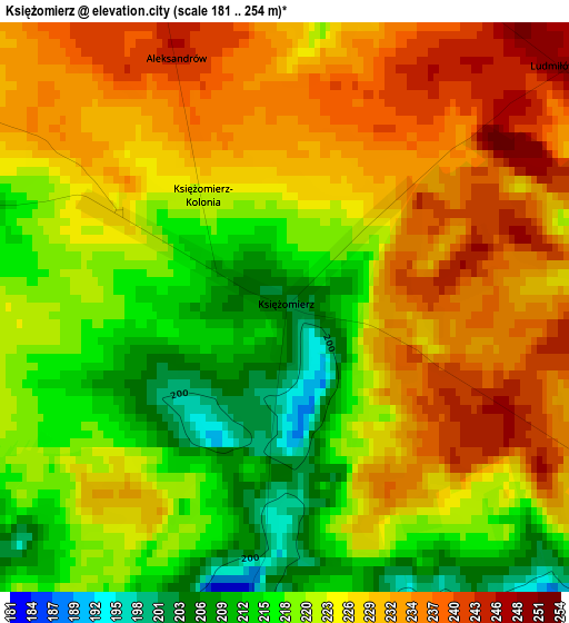
Below is the Elevation map of Księżomierz, which displays elevation range with different colors. Scale of the first map is from 181 to 254 m (594 to 833 ft) with average elevation of 224.4 meters (=736 ft) [note 1]
These maps also provides idea of topography and contour of this city, they are displayed at different zoom levels. More info about maps, scale and edge coordinates you can find below images.
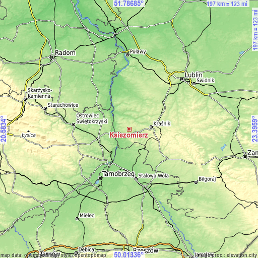
| \ | Map #1 | Topo.Map |
| Scale [m] | 181..254 m | × |
| Scale [ft] | 594..833 ft | × |
| Average | 224.4 m = 736 ft | × |
| Width | 6.16 km = 3.8 mi | 197.2 km = 122.5 mi |
| Height | 6.16 km = 3.8 mi | 197.2 km = 122.5 mi |
| ↑Max Latitude | 50.936252° | 51.78685° |
| Latitude at center | 50.90855° | 50.90855° |
| ↓Min Latitude | 50.880832° | 50.01336° |
| ← Min Longitude | 21.945705° | 20.5834° |
| Longitude center | 21.98965° | 21.98965° |
| →Max Longitude | 22.033595° | 23.3959° |
Nearby cities:
Cities around Księżomierz sort by population:
• Kraśnik elevation 199 m
16.7 km,  84°
84°
• Zaklików 180 m
18.5 km,  154°
154°
• Annopol 182 m
9.7 km,  254°
254°
• Zawichost 155 m
14.7 km,  220°
220°
• Chwałowice 140 m
17.4 km,  204°
204°
• Zdziechowice Drugie 187 m
16.1 km, 148°
• Józefów nad Wisłą 147 m
18.6 km,  323°
323°
• Gościeradów 174 m
4.6 km,  166°
166°
• Urzędów 184 m
14.3 km,  48°
48°
• Potok Wielki 207 m
20.6 km,  129°
129°
• Trzydnik Duży 210 m
12.1 km,  123°
123°
• Dzierzkowice 176 m
7.9 km,  43°
43°
Multilingual:
 En español:
Księżomierz elevación 202 m.
 En France:
Księżomierz élévation 202 m.
 Auf Deutsch:
Księżomierz höhe über dem Meeresspiegel ist 202 m.

Sources and notes:
- [note 1] Map square and city borders are not equal. Map elevation data is calculated only from area inside that square.
- [src 1] Elevation data from geonames database provided with same terms of usage.
- [src 2] The elevation map of Księżomierz is generated using elevation data from NASA's 3 arcsec (90m) resolution SRTM data.
- [src 3] Base (background) map © OpenStreetMap contributors tiles are generated by Geofabrik and OpenTopoMap.
Copyright & License:
This Księżomierz Elevation Map is licensed under CC BY-SA. You may reuse any part from this page, if you give a proper credit by linking to this URL:
 More info on terms of use page.