Masłów elevation
Masłów (Świętokrzyskie, Powiat kielecki), Poland elevation is 295 meters and Masłów elevation in feet is 968 ft above sea level [src 1]. Masłów is a seat of a third-order administrative division (feature code) with elevation that is 104 meters (341 ft) bigger than average city elevation in Poland.
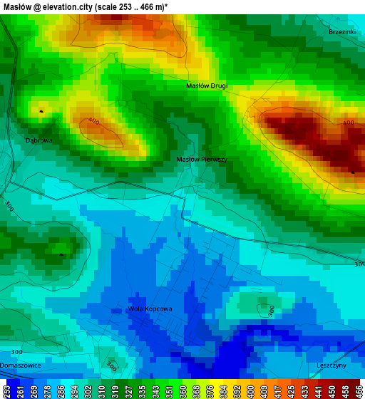
Below is the Elevation map of Masłów, which displays elevation range with different colors. Scale of the first map is from 253 to 466 m (830 to 1529 ft) with average elevation of 320.7 meters (=1052 ft) [note 1]
These maps also provides idea of topography and contour of this city, they are displayed at different zoom levels. More info about maps, scale and edge coordinates you can find below images.
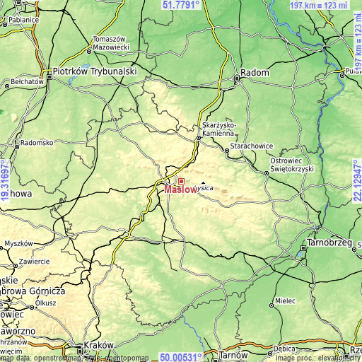
| \ | Map #1 | Topo.Map |
| Scale [m] | 253..466 m | × |
| Scale [ft] | 830..1529 ft | × |
| Average | 320.7 m = 1052 ft | × |
| Width | 6.16 km = 3.8 mi | 197.2 km = 122.5 mi |
| Height | 6.16 km = 3.8 mi | 197.2 km = 122.5 mi |
| ↑Max Latitude | 50.928357° | 51.7791° |
| Latitude at center | 50.90065° | 50.90065° |
| ↓Min Latitude | 50.872927° | 50.00531° |
| ← Min Longitude | 20.679275° | 19.31697° |
| Longitude center | 20.72322° | 20.72322° |
| →Max Longitude | 20.767165° | 22.12947° |
Nearby cities:
Cities around Masłów sort by population:
• Kielce elevation 267 m
7.5 km,  243°
243°
• Daleszyce 262 m
12.4 km,  151°
151°
• Osiedle-Nowiny 231 m
15.8 km,  234°
234°
• Miedziana Góra 307 m
12.7 km,  288°
288°
• Zagnańsk 319 m
9.8 km,  334°
334°
• Kostomłoty Pierwsze 273 m
9.3 km, 285°
• Kostomłoty Drugie 288 m
11.4 km,  284°
284°
• Górno 290 m
9.3 km,  129°
129°
• Wola Jachowa 276 m
11.3 km,  123°
123°
• Kaniów 314 m
10.3 km,  336°
336°
• Domaszowice 285 m
4 km,  224°
224°
• Łączna 295 m
12.4 km,  24°
24°
Multilingual:
 En español:
Masłów elevación 295 m.
 En France:
Masłów élévation 295 m.


Sources and notes:
- [note 1] Map square and city borders are not equal. Map elevation data is calculated only from area inside that square.
- [src 1] Elevation data from geonames database provided with same terms of usage.
- [src 2] The elevation map of Masłów is generated using elevation data from NASA's 3 arcsec (90m) resolution SRTM data.
- [src 3] Base (background) map © OpenStreetMap contributors tiles are generated by Geofabrik and OpenTopoMap.
Copyright & License:
This Masłów Elevation Map is licensed under CC BY-SA. You may reuse any part from this page, if you give a proper credit by linking to this URL:
 More info on terms of use page.