Wola Jachowa elevation
Wola Jachowa (Świętokrzyskie, Powiat kielecki), Poland elevation is 276 meters and Wola Jachowa elevation in feet is 906 ft above sea level [src 1]. Wola Jachowa is a populated place (feature code) with elevation that is 85 meters (279 ft) bigger than average city elevation in Poland.
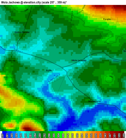
Below is the Elevation map of Wola Jachowa, which displays elevation range with different colors. Scale of the first map is from 257 to 359 m (843 to 1178 ft) with average elevation of 289.4 meters (=949 ft) [note 1]
These maps also provides idea of topography and contour of this city, they are displayed at different zoom levels. More info about maps, scale and edge coordinates you can find below images.
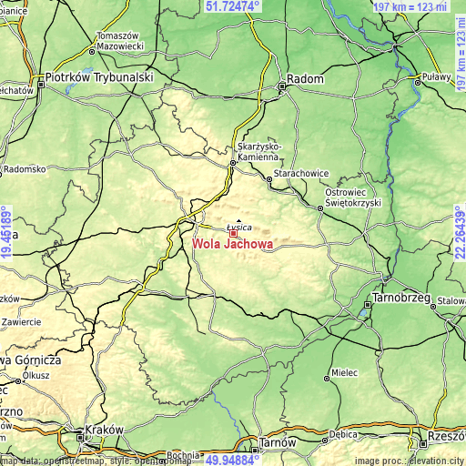
| \ | Map #1 | Topo.Map |
| Scale [m] | 257..359 m | × |
| Scale [ft] | 843..1178 ft | × |
| Average | 289.4 m = 949 ft | × |
| Width | 6.17 km = 3.8 mi | 197.5 km = 122.7 mi |
| Height | 6.17 km = 3.8 mi | 197.4 km = 122.7 mi |
| ↑Max Latitude | 50.87298° | 51.72474° |
| Latitude at center | 50.84524° | 50.84524° |
| ↓Min Latitude | 50.817484° | 49.94884° |
| ← Min Longitude | 20.814195° | 19.45189° |
| Longitude center | 20.85814° | 20.85814° |
| →Max Longitude | 20.902085° | 22.26439° |
Nearby cities:
Cities around Wola Jachowa sort by population:
• Kielce elevation 267 m
16.4 km,  279°
279°
• Daleszyce 262 m
5.9 km,  216°
216°
• Bodzentyn 287 m
12.7 km,  33°
33°
• Bieliny 306 m
5.9 km,  85°
85°
• Łagów 297 m
17.7 km,  116°
116°
• Morawica 226 m
20.1 km,  237°
237°
• Masłów 295 m
11.3 km,  303°
303°
• Górno 290 m
2.3 km, 276°
• Nowa Słupia 286 m
16.4 km,  82°
82°
• Pierzchnica 274 m
18 km,  203°
203°
• Domaszowice 285 m
12.7 km, 284°
• Łączna 295 m
18 km,  346°
346°
Multilingual:
 En español:
Wola Jachowa elevación 276 m.
 En France:
Wola Jachowa élévation 276 m.
 Auf Deutsch:
Wola Jachowa höhe über dem Meeresspiegel ist 276 m.

Sources and notes:
- [note 1] Map square and city borders are not equal. Map elevation data is calculated only from area inside that square.
- [src 1] Elevation data from geonames database provided with same terms of usage.
- [src 2] The elevation map of Wola Jachowa is generated using elevation data from NASA's 3 arcsec (90m) resolution SRTM data.
- [src 3] Base (background) map © OpenStreetMap contributors tiles are generated by Geofabrik and OpenTopoMap.
Copyright & License:
This Wola Jachowa Elevation Map is licensed under CC BY-SA. You may reuse any part from this page, if you give a proper credit by linking to this URL:
 More info on terms of use page.