Zagnańsk elevation
Zagnańsk (Świętokrzyskie, Powiat kielecki), Poland elevation is 319 meters and Zagnańsk elevation in feet is 1047 ft above sea level [src 1]. Zagnańsk is a seat of a third-order administrative division (feature code) with elevation that is 128 meters (420 ft) bigger than average city elevation in Poland.
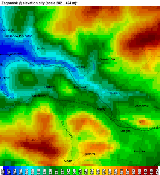
Below is the Elevation map of Zagnańsk, which displays elevation range with different colors. Scale of the first map is from 282 to 424 m (925 to 1391 ft) with average elevation of 349.1 meters (=1145 ft) [note 1]
These maps also provides idea of topography and contour of this city, they are displayed at different zoom levels. More info about maps, scale and edge coordinates you can find below images.
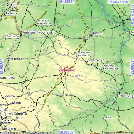
| \ | Map #1 | Topo.Map |
| Scale [m] | 282..424 m | × |
| Scale [ft] | 925..1391 ft | × |
| Average | 349.1 m = 1145 ft | × |
| Width | 6.15 km = 3.8 mi | 196.9 km = 122.3 mi |
| Height | 6.15 km = 3.8 mi | 196.9 km = 122.3 mi |
| ↑Max Latitude | 51.008029° | 51.8573° |
| Latitude at center | 50.98037° | 50.98037° |
| ↓Min Latitude | 50.952694° | 50.08655° |
| ← Min Longitude | 20.619195° | 19.25689° |
| Longitude center | 20.66314° | 20.66314° |
| →Max Longitude | 20.707085° | 22.06939° |
Nearby cities:
Cities around Zagnańsk sort by population:
• Kielce elevation 267 m
12.5 km,  191°
191°
• Suchedniów 265 m
13.8 km,  57°
57°
• Miedziana Góra 307 m
9.2 km,  238°
238°
• Bliżyn 265 m
15.7 km,  25°
25°
• Mniów 275 m
13 km,  285°
285°
• Kostomłoty Pierwsze 273 m
8 km,  216°
216°
• Masłów 295 m
9.8 km,  154°
154°
• Kostomłoty Drugie 288 m
9.1 km,  229°
229°
• Kaniów 314 m
0.6 km,  5°
5°
• Domaszowice 285 m
11.8 km,  173°
173°
• Strawczyn 256 m
17.5 km,  255°
255°
• Łączna 295 m
9.7 km,  75°
75°
Multilingual:
 En español:
Zagnańsk elevación 319 m.
 En France:
Zagnańsk élévation 319 m.
 Auf Deutsch:
Zagnańsk höhe über dem Meeresspiegel ist 319 m.

Sources and notes:
- [note 1] Map square and city borders are not equal. Map elevation data is calculated only from area inside that square.
- [src 1] Elevation data from geonames database provided with same terms of usage.
- [src 2] The elevation map of Zagnańsk is generated using elevation data from NASA's 3 arcsec (90m) resolution SRTM data.
- [src 3] Base (background) map © OpenStreetMap contributors tiles are generated by Geofabrik and OpenTopoMap.
Copyright & License:
This Zagnańsk Elevation Map is licensed under CC BY-SA. You may reuse any part from this page, if you give a proper credit by linking to this URL:
 More info on terms of use page.