Biały Bór elevation
Biały Bór (West Pomerania, Powiat szczecinecki), Poland elevation is 158 meters and Biały Bór elevation in feet is 518 ft above sea level [src 1]. Biały Bór is a seat of a third-order administrative division (feature code) with elevation that is 33 meters (108 ft) smaller than average city elevation in Poland.
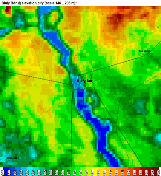
Below is the Elevation map of Biały Bór, which displays elevation range with different colors. Scale of the first map is from 146 to 205 m (479 to 673 ft) with average elevation of 173.9 meters (=571 ft) [note 1]
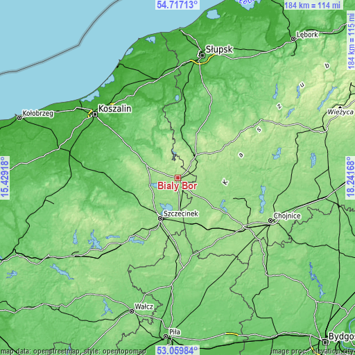
These maps also provides idea of topography and contour of this city, they are displayed at different zoom levels. More info about maps, scale and edge coordinates you can find below images.
| \ | Map #1 | Topo.Map |
| Scale [m] | 146..205 m | × |
| Scale [ft] | 479..673 ft | × |
| Average | 173.9 m = 571 ft | × |
| Width | 5.76 km = 3.6 mi | 184.3 km = 114.5 mi |
| Height | 5.76 km = 3.6 mi | 184.3 km = 114.5 mi |
| ↑Max Latitude | 53.922586° | 54.71713° |
| Latitude at center | 53.8967° | 53.8967° |
| ↓Min Latitude | 53.870798° | 53.05984° |
| ← Min Longitude | 16.791485° | 15.42918° |
| Longitude center | 16.83543° | 16.83543° |
| →Max Longitude | 16.879375° | 18.24168° |
Nearby cities:
Cities around Biały Bór sort by population:
• Szczecinek elevation 139 m
22.8 km,  203°
203°
• Miastko 125 m
15.2 km,  39°
39°
• Czarne 128 m
24.6 km,  164°
164°
• Bobolice 122 m
17.4 km,  291°
291°
• Barwice 114 m
35.7 km,  241°
241°
• Polanów 79 m
26.6 km,  338°
338°
• Przechlewo 149 m
29.4 km,  111°
111°
• Tychowo 69 m
38 km,  275°
275°
• Koczała 152 m
15.1 km,  86°
86°
• Rzeczenica 150 m
23.6 km,  130°
130°
• Grzmiąca 112 m
27.1 km,  255°
255°
• Trzebielino 86 m
37.5 km,  25°
25°
Multilingual:
 En español:
Biały Bór elevación 158 m.
 En France:
Biały Bór élévation 158 m.
 Auf Deutsch:
Biały Bór höhe über dem Meeresspiegel ist 158 m.

Sources and notes:
- [note 1] Map square and city borders are not equal. Map elevation data is calculated only from area inside that square.
- [src 1] Elevation data from geonames database provided with same terms of usage.
- [src 2] The elevation map of Biały Bór is generated using elevation data from NASA's 3 arcsec (90m) resolution SRTM data.
- [src 3] Base (background) map © OpenStreetMap contributors tiles are generated by Geofabrik and OpenTopoMap.
Copyright & License:
This Biały Bór Elevation Map is licensed under CC BY-SA. You may reuse any part from this page, if you give a proper credit by linking to this URL:
 More info on terms of use page.