Grzmiąca elevation
Grzmiąca (West Pomerania, Powiat szczecinecki), Poland elevation is 112 meters and Grzmiąca elevation in feet is 367 ft above sea level [src 1]. Grzmiąca is a populated place (feature code) with elevation that is 79 meters (259 ft) smaller than average city elevation in Poland.
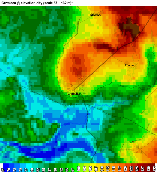
Below is the Elevation map of Grzmiąca, which displays elevation range with different colors. Scale of the first map is from 67 to 132 m (220 to 433 ft) with average elevation of 94.3 meters (=309 ft) [note 1]
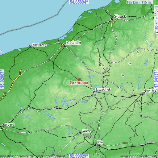
These maps also provides idea of topography and contour of this city, they are displayed at different zoom levels. More info about maps, scale and edge coordinates you can find below images.
| \ | Map #1 | Topo.Map |
| Scale [m] | 67..132 m | × |
| Scale [ft] | 220..433 ft | × |
| Average | 94.3 m = 309 ft | × |
| Width | 5.77 km = 3.6 mi | 184.5 km = 114.6 mi |
| Height | 5.77 km = 3.6 mi | 184.5 km = 114.6 mi |
| ↑Max Latitude | 53.863263° | 54.65894° |
| Latitude at center | 53.83734° | 53.83734° |
| ↓Min Latitude | 53.811401° | 52.99929° |
| ← Min Longitude | 16.391175° | 15.02887° |
| Longitude center | 16.43512° | 16.43512° |
| →Max Longitude | 16.479065° | 17.84137° |
Nearby cities:
Cities around Grzmiąca sort by population:
• Szczecinek elevation 139 m
22.6 km,  129°
129°
• Białogard 25 m
34.9 km,  302°
302°
• Połczyn-Zdrój 92 m
23.7 km,  249°
249°
• Czaplinek 145 m
33.8 km,  203°
203°
• Bobolice 122 m
16.5 km,  37°
37°
• Borne Sulinowo 142 m
29.7 km,  167°
167°
• Barwice 114 m
11.5 km,  207°
207°
• Polanów 79 m
35.4 km,  27°
27°
• Tychowo 69 m
15.4 km,  310°
310°
• Biały Bór 158 m
27.1 km,  75°
75°
• Łubowo 148 m
28.1 km,  185°
185°
• Rąbino 107 m
32.3 km,  275°
275°
Multilingual:
 En español:
Grzmiąca elevación 112 m.
 En France:
Grzmiąca élévation 112 m.
 Auf Deutsch:
Grzmiąca höhe über dem Meeresspiegel ist 112 m.

Sources and notes:
- [note 1] Map square and city borders are not equal. Map elevation data is calculated only from area inside that square.
- [src 1] Elevation data from geonames database provided with same terms of usage.
- [src 2] The elevation map of Grzmiąca is generated using elevation data from NASA's 3 arcsec (90m) resolution SRTM data.
- [src 3] Base (background) map © OpenStreetMap contributors tiles are generated by Geofabrik and OpenTopoMap.
Copyright & License:
This Grzmiąca Elevation Map is licensed under CC BY-SA. You may reuse any part from this page, if you give a proper credit by linking to this URL:
 More info on terms of use page.