Tychowo elevation
Tychowo (West Pomerania, Powiat białogardzki), Poland elevation is 69 meters and Tychowo elevation in feet is 226 ft above sea level [src 1]. Tychowo is a seat of a third-order administrative division (feature code) with elevation that is 122 meters (400 ft) smaller than average city elevation in Poland.
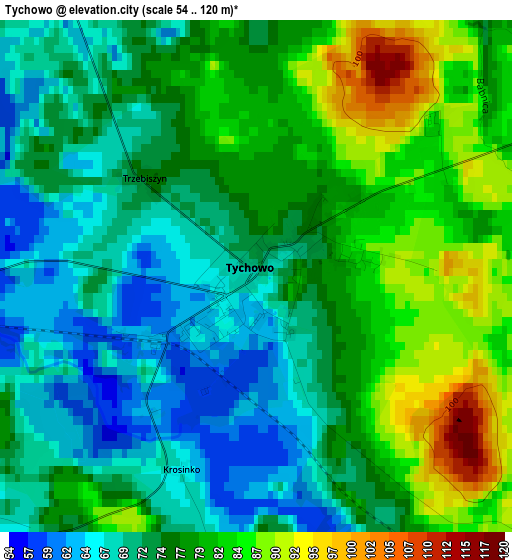
Below is the Elevation map of Tychowo, which displays elevation range with different colors. Scale of the first map is from 54 to 120 m (177 to 394 ft) with average elevation of 75.9 meters (=249 ft) [note 1]
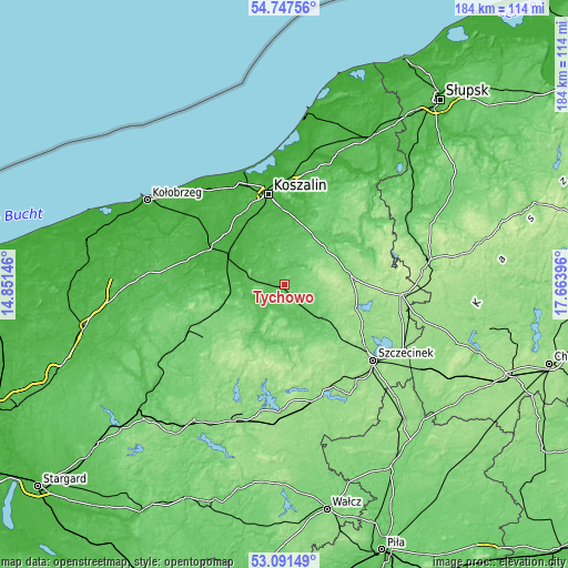
These maps also provides idea of topography and contour of this city, they are displayed at different zoom levels. More info about maps, scale and edge coordinates you can find below images.
| \ | Map #1 | Topo.Map |
| Scale [m] | 54..120 m | × |
| Scale [ft] | 177..394 ft | × |
| Average | 75.9 m = 249 ft | × |
| Width | 5.75 km = 3.6 mi | 184.1 km = 114.4 mi |
| Height | 5.75 km = 3.6 mi | 184.1 km = 114.4 mi |
| ↑Max Latitude | 53.953607° | 54.74756° |
| Latitude at center | 53.92774° | 53.92774° |
| ↓Min Latitude | 53.901857° | 53.09149° |
| ← Min Longitude | 16.213765° | 14.85146° |
| Longitude center | 16.25771° | 16.25771° |
| →Max Longitude | 16.301655° | 17.66396° |
Nearby cities:
Cities around Tychowo sort by population:
• Koszalin elevation 30 m
30.2 km,  349°
349°
• Białogard 25 m
19.7 km,  296°
296°
• Świdwin 92 m
35.8 km,  241°
241°
• Połczyn-Zdrój 92 m
21.1 km,  210°
210°
• Sianów 7 m
33.3 km,  3°
3°
• Karlino 17 m
27.6 km, 295°
• Bobolice 122 m
21.9 km,  82°
82°
• Barwice 114 m
21.3 km,  162°
162°
• Polanów 79 m
35.1 km,  52°
52°
• Sławoborze 49 m
36.3 km,  263°
263°
• Grzmiąca 112 m
15.4 km,  130°
130°
• Rąbino 107 m
21.6 km,  251°
251°
Multilingual:
 En español:
Tychowo elevación 69 m.
 En France:
Tychowo élévation 69 m.


Sources and notes:
- [note 1] Map square and city borders are not equal. Map elevation data is calculated only from area inside that square.
- [src 1] Elevation data from geonames database provided with same terms of usage.
- [src 2] The elevation map of Tychowo is generated using elevation data from NASA's 3 arcsec (90m) resolution SRTM data.
- [src 3] Base (background) map © OpenStreetMap contributors tiles are generated by Geofabrik and OpenTopoMap.
Copyright & License:
This Tychowo Elevation Map is licensed under CC BY-SA. You may reuse any part from this page, if you give a proper credit by linking to this URL:
 More info on terms of use page.