Sławoborze elevation
Sławoborze (West Pomerania, Powiat świdwiński), Poland elevation is 49 meters and Sławoborze elevation in feet is 161 ft above sea level [src 1]. Sławoborze is a populated place (feature code) with elevation that is 142 meters (466 ft) smaller than average city elevation in Poland.
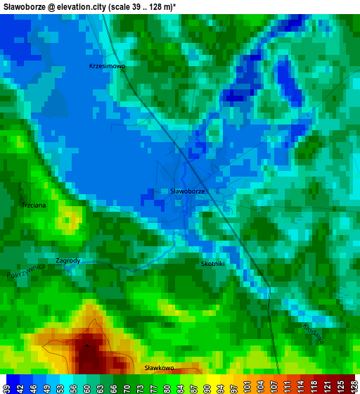
Below is the Elevation map of Sławoborze, which displays elevation range with different colors. Scale of the first map is from 39 to 128 m (128 to 420 ft) with average elevation of 63.8 meters (=209 ft) [note 1]
These maps also provides idea of topography and contour of this city, they are displayed at different zoom levels. More info about maps, scale and edge coordinates you can find below images.
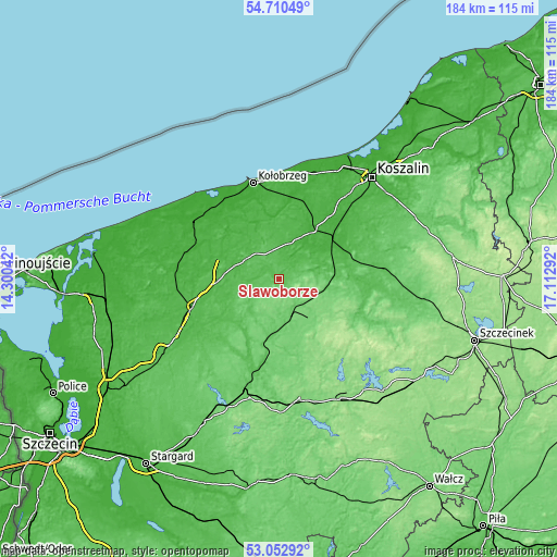
| \ | Map #1 | Topo.Map |
| Scale [m] | 39..128 m | × |
| Scale [ft] | 128..420 ft | × |
| Average | 63.8 m = 209 ft | × |
| Width | 5.76 km = 3.6 mi | 184.3 km = 114.5 mi |
| Height | 5.76 km = 3.6 mi | 184.3 km = 114.5 mi |
| ↑Max Latitude | 53.915811° | 54.71049° |
| Latitude at center | 53.88992° | 53.88992° |
| ↓Min Latitude | 53.864013° | 53.05292° |
| ← Min Longitude | 15.662725° | 14.30042° |
| Longitude center | 15.70667° | 15.70667° |
| →Max Longitude | 15.750615° | 17.11292° |
Nearby cities:
Cities around Sławoborze sort by population:
• Białogard elevation 25 m
22.5 km,  54°
54°
• Świdwin 92 m
13.6 km,  160°
160°
• Łobez 63 m
28.4 km,  191°
191°
• Połczyn-Zdrój 92 m
29.1 km,  118°
118°
• Karlino 17 m
19.6 km,  34°
34°
• Resko 41 m
23.6 km,  236°
236°
• Gościno 40 m
18.3 km,  348°
348°
• Dygowo 28 m
26.7 km,  1°
1°
• Brojce 33 m
23.9 km,  288°
288°
• Radowo Małe 92 m
30.2 km,  214°
214°
• Rymań 52 m
13.1 km,  297°
297°
• Rąbino 107 m
15.8 km,  99°
99°
Multilingual:
 En español:
Sławoborze elevación 49 m.
 En France:
Sławoborze élévation 49 m.
 Auf Deutsch:
Sławoborze höhe über dem Meeresspiegel ist 49 m.

Sources and notes:
- [note 1] Map square and city borders are not equal. Map elevation data is calculated only from area inside that square.
- [src 1] Elevation data from geonames database provided with same terms of usage.
- [src 2] The elevation map of Sławoborze is generated using elevation data from NASA's 3 arcsec (90m) resolution SRTM data.
- [src 3] Base (background) map © OpenStreetMap contributors tiles are generated by Geofabrik and OpenTopoMap.
Copyright & License:
This Sławoborze Elevation Map is licensed under CC BY-SA. You may reuse any part from this page, if you give a proper credit by linking to this URL:
 More info on terms of use page.