Czarne elevation
Czarne (Pomerania, Powiat człuchowski), Poland elevation is 128 meters and Czarne elevation in feet is 420 ft above sea level [src 1]. Czarne is a seat of a third-order administrative division (feature code) with elevation that is 63 meters (207 ft) smaller than average city elevation in Poland.
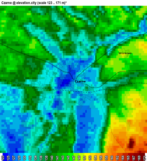
Below is the Elevation map of Czarne, which displays elevation range with different colors. Scale of the first map is from 123 to 171 m (404 to 561 ft) with average elevation of 138.2 meters (=453 ft) [note 1]
These maps also provides idea of topography and contour of this city, they are displayed at different zoom levels. More info about maps, scale and edge coordinates you can find below images.
| \ | Map #1 | Map #2 | Topo.Map |
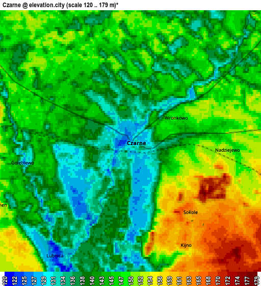
| Scale [m] | 123..171 m | 120..179 m | × |
| Scale [ft] | 404..561 ft | 394..587 ft | × |
| Average | 138.2 m = 453 ft | 144.6 m = 474 ft | × |
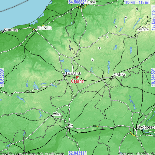
| Width | 5.79 km = 3.6 mi | 11.58 km = 7.2 mi | 185.2 km = 115.1 mi |
| Height | 5.79 km = 3.6 mi | 11.58 km = 7.2 mi | 185.2 km = 115.1 mi |
| ↑Max Latitude | 53.710218° | 53.73622° | 54.50882° |
| Latitude at center | 53.6842° | 53.6842° | 53.6842° |
| ↓Min Latitude | 53.658166° | 53.632116° | 52.84311° |
| ← Min Longitude | 16.894395° | 16.850449° | 15.53209° |
| Longitude center | 16.93834° | 16.93834° | 16.93834° |
| →Max Longitude | 16.982285° | 17.026231° | 18.34459° |
Nearby cities:
Cities around Czarne sort by population:
• Szczecinek elevation 139 m
16 km,  279°
279°
• Człuchów 164 m
27.8 km,  93°
93°
• Jastrowie 97 m
30.4 km,  195°
195°
• Debrzno 155 m
25.5 km,  129°
129°
• Borne Sulinowo 142 m
29.2 km,  245°
245°
• Okonek 127 m
17.4 km, 199°
• Przechlewo 149 m
24.2 km,  58°
58°
• Biały Bór 158 m
24.6 km,  344°
344°
• Lipka 142 m
29.4 km,  135°
135°
• Koczała 152 m
25.9 km,  18°
18°
• Rzeczenica 150 m
13.8 km,  53°
53°
• Sypniewo 136 m
32.5 km,  222°
222°
Multilingual:
 En español:
Czarne elevación 128 m.
 En France:
Czarne élévation 128 m.


Sources and notes:
- [note 1] Map square and city borders are not equal. Map elevation data is calculated only from area inside that square.
- [src 1] Elevation data from geonames database provided with same terms of usage.
- [src 2] The elevation map of Czarne is generated using elevation data from NASA's 3 arcsec (90m) resolution SRTM data.
- [src 3] Base (background) map © OpenStreetMap contributors tiles are generated by Geofabrik and OpenTopoMap.
Copyright & License:
This Czarne Elevation Map is licensed under CC BY-SA. You may reuse any part from this page, if you give a proper credit by linking to this URL:
 More info on terms of use page.