Brusy elevation
Brusy (Pomerania, Powiat chojnicki), Poland elevation is 147 meters and Brusy elevation in feet is 482 ft above sea level [src 1]. Brusy is a populated place (feature code) with elevation that is 44 meters (144 ft) smaller than average city elevation in Poland.
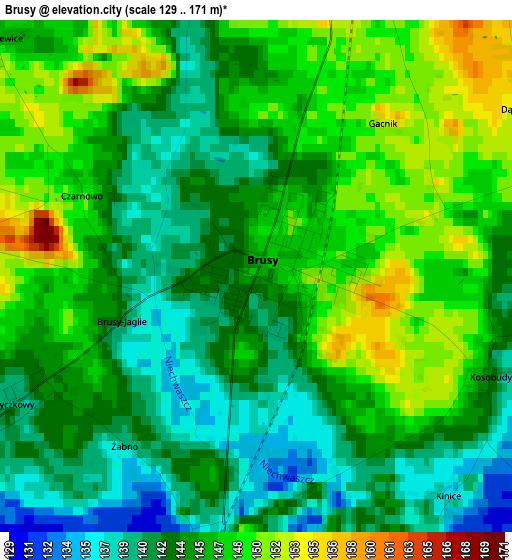
Below is the Elevation map of Brusy, which displays elevation range with different colors. Scale of the first map is from 129 to 171 m (423 to 561 ft) with average elevation of 144.8 meters (=475 ft) [note 1]
These maps also provides idea of topography and contour of this city, they are displayed at different zoom levels. More info about maps, scale and edge coordinates you can find below images.
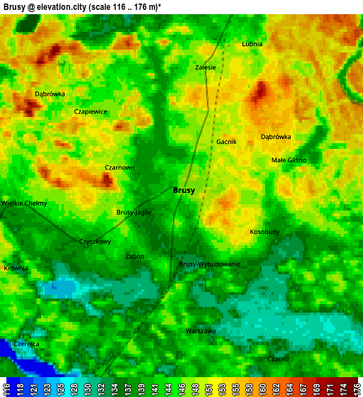
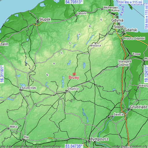
| \ | Map #1 | Map #2 | Topo.Map |
| Scale [m] | 129..171 m | 116..176 m | × |
| Scale [ft] | 423..561 ft | 381..577 ft | × |
| Average | 144.8 m = 475 ft | 144.4 m = 474 ft | × |
| Width | 5.76 km = 3.6 mi | 11.52 km = 7.2 mi | 184.3 km = 114.5 mi |
| Height | 5.76 km = 3.6 mi | 11.52 km = 7.2 mi | 184.3 km = 114.5 mi |
| ↑Max Latitude | 53.910354° | 53.936232° | 54.70513° |
| Latitude at center | 53.88446° | 53.88446° | 53.88446° |
| ↓Min Latitude | 53.85855° | 53.832624° | 53.04735° |
| ← Min Longitude | 17.673915° | 17.629969° | 16.31161° |
| Longitude center | 17.71786° | 17.71786° | 17.71786° |
| →Max Longitude | 17.761805° | 17.805751° | 19.12411° |
Nearby cities:
Cities around Brusy sort by population:
• Chojnice elevation 152 m
23.5 km,  206°
206°
• Kościerzyna 162 m
31.5 km,  33°
33°
• Czersk 130 m
19.6 km,  120°
120°
• Czarna Woda 121 m
25.4 km,  100°
100°
• Przechlewo 149 m
32 km,  252°
252°
• Karsin 146 m
13.6 km,  79°
79°
• Lipusz 150 m
24.1 km,  10°
10°
• Dziemiany 163 m
13.9 km, 13°
• Stara Kiszewa 122 m
31.8 km,  68°
68°
• Szlachta 123 m
29 km, 116°
• Studzienice 165 m
24.9 km,  338°
338°
• Lipnica 171 m
23.8 km,  301°
301°
Multilingual:
 En español:
Brusy elevación 147 m.
 En France:
Brusy élévation 147 m.


Sources and notes:
- [note 1] Map square and city borders are not equal. Map elevation data is calculated only from area inside that square.
- [src 1] Elevation data from geonames database provided with same terms of usage.
- [src 2] The elevation map of Brusy is generated using elevation data from NASA's 3 arcsec (90m) resolution SRTM data.
- [src 3] Base (background) map © OpenStreetMap contributors tiles are generated by Geofabrik and OpenTopoMap.
Copyright & License:
This Brusy Elevation Map is licensed under CC BY-SA. You may reuse any part from this page, if you give a proper credit by linking to this URL:
 More info on terms of use page.