Lipnica elevation
Lipnica (Pomerania, Powiat bytowski), Poland elevation is 171 meters and Lipnica elevation in feet is 561 ft above sea level [src 1]. Lipnica is a seat of a third-order administrative division (feature code) with elevation that is 20 meters (66 ft) smaller than average city elevation in Poland.
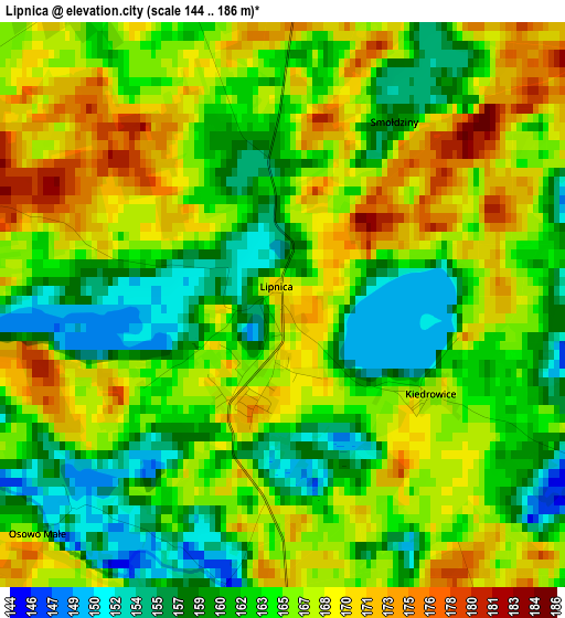
Below is the Elevation map of Lipnica, which displays elevation range with different colors. Scale of the first map is from 144 to 186 m (472 to 610 ft) with average elevation of 164.5 meters (=540 ft) [note 1]
These maps also provides idea of topography and contour of this city, they are displayed at different zoom levels. More info about maps, scale and edge coordinates you can find below images.
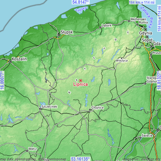
| \ | Map #1 | Topo.Map |
| Scale [m] | 144..186 m | × |
| Scale [ft] | 472..610 ft | × |
| Average | 164.5 m = 540 ft | × |
| Width | 5.74 km = 3.6 mi | 183.8 km = 114.2 mi |
| Height | 5.74 km = 3.6 mi | 183.8 km = 114.2 mi |
| ↑Max Latitude | 54.022055° | 54.8147° |
| Latitude at center | 53.99623° | 53.99623° |
| ↓Min Latitude | 53.970389° | 53.16135° |
| ← Min Longitude | 17.363075° | 16.00077° |
| Longitude center | 17.40702° | 17.40702° |
| →Max Longitude | 17.450965° | 18.81327° |
Nearby cities:
Cities around Lipnica sort by population:
• Bytów elevation 122 m
20.2 km,  15°
15°
• Miastko 125 m
27.7 km,  271°
271°
• Brusy 147 m
23.8 km,  121°
121°
• Przechlewo 149 m
24.2 km,  204°
204°
• Koczała 152 m
24.6 km,  245°
245°
• Lipusz 150 m
27.1 km,  65°
65°
• Dziemiany 163 m
23.6 km,  87°
87°
• Tuchomie 148 m
14 km,  340°
340°
• Kołczygłowy 114 m
29.3 km, 337°
• Parchowo 188 m
28.9 km,  36°
36°
• Borzytuchom 112 m
22.8 km,  353°
353°
• Studzienice 165 m
15.4 km,  45°
45°
Multilingual:
 En español:
Lipnica elevación 171 m.
 En France:
Lipnica élévation 171 m.


Sources and notes:
- [note 1] Map square and city borders are not equal. Map elevation data is calculated only from area inside that square.
- [src 1] Elevation data from geonames database provided with same terms of usage.
- [src 2] The elevation map of Lipnica is generated using elevation data from NASA's 3 arcsec (90m) resolution SRTM data.
- [src 3] Base (background) map © OpenStreetMap contributors tiles are generated by Geofabrik and OpenTopoMap.
Copyright & License:
This Lipnica Elevation Map is licensed under CC BY-SA. You may reuse any part from this page, if you give a proper credit by linking to this URL:
 More info on terms of use page.