Chojnice elevation
Chojnice (Pomerania, Powiat chojnicki), Poland elevation is 152 meters and Chojnice elevation in feet is 499 ft above sea level [src 1]. Chojnice is a populated place (feature code) with elevation that is 39 meters (128 ft) smaller than average city elevation in Poland.
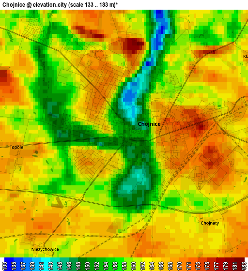
Below is the Elevation map of Chojnice, which displays elevation range with different colors. Scale of the first map is from 133 to 183 m (436 to 600 ft) with average elevation of 161.9 meters (=531 ft) [note 1]
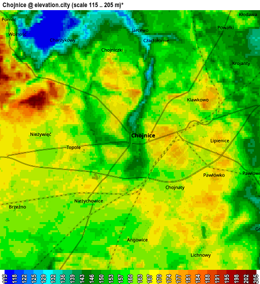
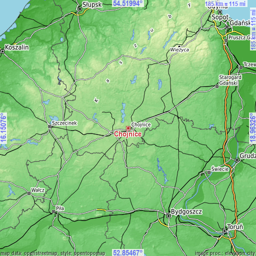
These maps also provides idea of topography and contour of this city, they are displayed at different zoom levels. More info about maps, scale and edge coordinates you can find below images.
| \ | Map #1 | Map #2 | Topo.Map |
| Scale [m] | 133..183 m | 115..205 m | × |
| Scale [ft] | 436..600 ft | 377..673 ft | × |
| Average | 161.9 m = 531 ft | 159.3 m = 523 ft | × |
| Width | 5.79 km = 3.6 mi | 11.57 km = 7.2 mi | 185.2 km = 115.1 mi |
| Height | 5.79 km = 3.6 mi | 11.57 km = 7.2 mi | 185.1 km = 115 mi |
| ↑Max Latitude | 53.721551° | 53.747546° | 54.51994° |
| Latitude at center | 53.69554° | 53.69554° | 53.69554° |
| ↓Min Latitude | 53.669513° | 53.64347° | 52.85467° |
| ← Min Longitude | 17.513065° | 17.469119° | 16.15076° |
| Longitude center | 17.55701° | 17.55701° | 17.55701° |
| →Max Longitude | 17.600955° | 17.644901° | 18.96326° |
Nearby cities:
Cities around Chojnice sort by population:
• Człuchów elevation 164 m
13.4 km,  256°
256°
• Tuchola 109 m
23.2 km,  121°
121°
• Czersk 130 m
29.8 km,  67°
67°
• Sępólno Krajeńskie 119 m
27.1 km,  183°
183°
• Debrzno 155 m
27.4 km,  230°
230°
• Brusy 147 m
23.5 km,  26°
26°
• Przechlewo 149 m
23.1 km,  299°
299°
• Kamień Krajeński 130 m
18.2 km,  187°
187°
• Lipka 142 m
30 km,  222°
222°
• Gostycyn 111 m
28.3 km,  143°
143°
• Rzeczenica 150 m
30.4 km,  283°
283°
• Kęsowo 120 m
18.5 km,  145°
145°
Multilingual:
 En español:
Chojnice elevación 152 m.
 En France:
Chojnice élévation 152 m.


Sources and notes:
- [note 1] Map square and city borders are not equal. Map elevation data is calculated only from area inside that square.
- [src 1] Elevation data from geonames database provided with same terms of usage.
- [src 2] The elevation map of Chojnice is generated using elevation data from NASA's 3 arcsec (90m) resolution SRTM data.
- [src 3] Base (background) map © OpenStreetMap contributors tiles are generated by Geofabrik and OpenTopoMap.
Copyright & License:
This Chojnice Elevation Map is licensed under CC BY-SA. You may reuse any part from this page, if you give a proper credit by linking to this URL:
 More info on terms of use page.