Stara Kiszewa elevation
Stara Kiszewa (Pomerania, Powiat kościerski), Poland elevation is 122 meters and Stara Kiszewa elevation in feet is 400 ft above sea level [src 1]. Stara Kiszewa is a populated place (feature code) with elevation that is 69 meters (226 ft) smaller than average city elevation in Poland.
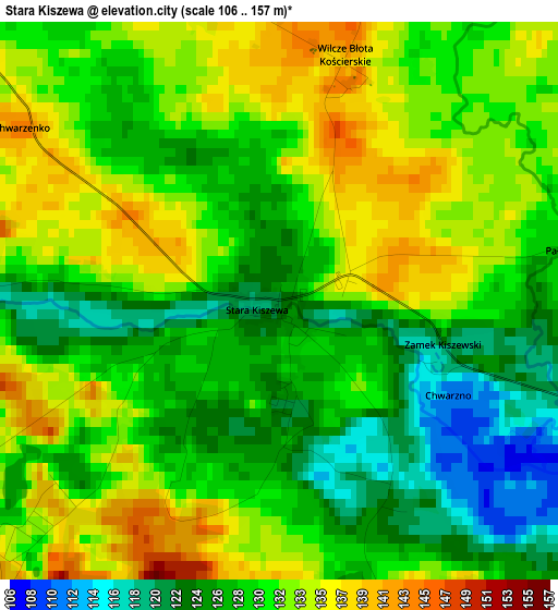
Below is the Elevation map of Stara Kiszewa, which displays elevation range with different colors. Scale of the first map is from 106 to 157 m (348 to 515 ft) with average elevation of 129.7 meters (=426 ft) [note 1]
These maps also provides idea of topography and contour of this city, they are displayed at different zoom levels. More info about maps, scale and edge coordinates you can find below images.
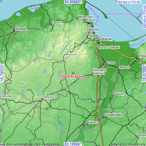
| \ | Map #1 | Topo.Map |
| Scale [m] | 106..157 m | × |
| Scale [ft] | 348..515 ft | × |
| Average | 129.7 m = 426 ft | × |
| Width | 5.75 km = 3.6 mi | 183.9 km = 114.3 mi |
| Height | 5.75 km = 3.6 mi | 183.8 km = 114.2 mi |
| ↑Max Latitude | 54.015889° | 54.80865° |
| Latitude at center | 53.99006° | 53.99006° |
| ↓Min Latitude | 53.964215° | 53.15506° |
| ← Min Longitude | 18.125635° | 16.76333° |
| Longitude center | 18.16958° | 18.16958° |
| →Max Longitude | 18.213525° | 19.57583° |
Nearby cities:
Cities around Stara Kiszewa sort by population:
• Starogard Gdański elevation 90 m
23.5 km,  97°
97°
• Kościerzyna 162 m
19.2 km,  320°
320°
• Skarszewy 112 m
20 km,  63°
63°
• Zblewo 115 m
11.8 km,  122°
122°
• Czarna Woda 121 m
16.8 km,  195°
195°
• Karsin 146 m
18.7 km,  240°
240°
• Lubichowo 103 m
21.5 km,  135°
135°
• Kaliska 143 m
10 km,  161°
161°
• Przywidz 202 m
24.9 km,  23°
23°
• Szlachta 123 m
24.9 km,  188°
188°
• Grabowo Kościerskie 200 m
19.9 km,  355°
355°
• Liniewo 149 m
10.3 km, 21°
Multilingual:
 En español:
Stara Kiszewa elevación 122 m.
 En France:
Stara Kiszewa élévation 122 m.
 Auf Deutsch:
Stara Kiszewa höhe über dem Meeresspiegel ist 122 m.

Sources and notes:
- [note 1] Map square and city borders are not equal. Map elevation data is calculated only from area inside that square.
- [src 1] Elevation data from geonames database provided with same terms of usage.
- [src 2] The elevation map of Stara Kiszewa is generated using elevation data from NASA's 3 arcsec (90m) resolution SRTM data.
- [src 3] Base (background) map © OpenStreetMap contributors tiles are generated by Geofabrik and OpenTopoMap.
Copyright & License:
This Stara Kiszewa Elevation Map is licensed under CC BY-SA. You may reuse any part from this page, if you give a proper credit by linking to this URL:
 More info on terms of use page.