Liniewo elevation
Liniewo (Pomerania, Powiat kościerski), Poland elevation is 149 meters and Liniewo elevation in feet is 489 ft above sea level [src 1]. Liniewo is a populated place (feature code) with elevation that is 42 meters (138 ft) smaller than average city elevation in Poland.
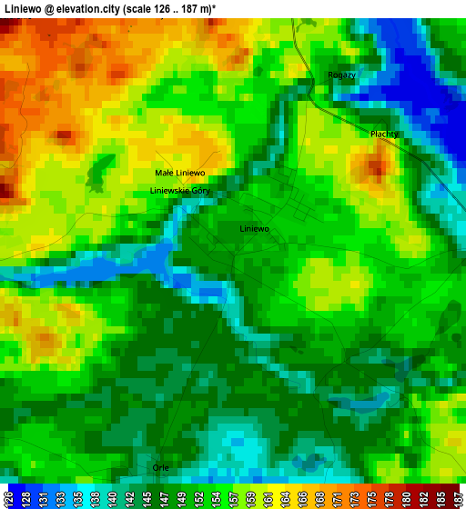
Below is the Elevation map of Liniewo, which displays elevation range with different colors. Scale of the first map is from 126 to 187 m (413 to 614 ft) with average elevation of 152.1 meters (=499 ft) [note 1]
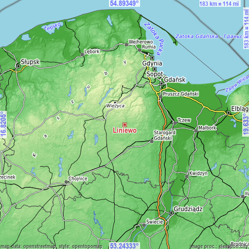
These maps also provides idea of topography and contour of this city, they are displayed at different zoom levels. More info about maps, scale and edge coordinates you can find below images.
| \ | Map #1 | Topo.Map |
| Scale [m] | 126..187 m | × |
| Scale [ft] | 413..614 ft | × |
| Average | 152.1 m = 499 ft | × |
| Width | 5.73 km = 3.6 mi | 183.5 km = 114 mi |
| Height | 5.73 km = 3.6 mi | 183.5 km = 114 mi |
| ↑Max Latitude | 54.102385° | 54.89349° |
| Latitude at center | 54.07661° | 54.07661° |
| ↓Min Latitude | 54.050819° | 53.24333° |
| ← Min Longitude | 18.182805° | 16.8205° |
| Longitude center | 18.22675° | 18.22675° |
| →Max Longitude | 18.270695° | 19.633° |
Nearby cities:
Cities around Liniewo sort by population:
• Starogard Gdański elevation 90 m
23.2 km,  122°
122°
• Kościerzyna 162 m
16.8 km,  287°
287°
• Skarszewy 112 m
14.2 km,  93°
93°
• Zblewo 115 m
17.1 km,  158°
158°
• Kolbudy 78 m
26.6 km,  35°
35°
• Kaliska 143 m
19 km,  181°
181°
• Somonino 165 m
22.2 km,  355°
355°
• Stężyca 165 m
22.8 km,  309°
309°
• Przywidz 202 m
14.6 km,  24°
24°
• Stara Kiszewa 122 m
10.3 km,  201°
201°
• Trąbki Wielkie 103 m
22.9 km,  62°
62°
• Grabowo Kościerskie 200 m
11.4 km,  332°
332°
Multilingual:
 En español:
Liniewo elevación 149 m.
 En France:
Liniewo élévation 149 m.


Sources and notes:
- [note 1] Map square and city borders are not equal. Map elevation data is calculated only from area inside that square.
- [src 1] Elevation data from geonames database provided with same terms of usage.
- [src 2] The elevation map of Liniewo is generated using elevation data from NASA's 3 arcsec (90m) resolution SRTM data.
- [src 3] Base (background) map © OpenStreetMap contributors tiles are generated by Geofabrik and OpenTopoMap.
Copyright & License:
This Liniewo Elevation Map is licensed under CC BY-SA. You may reuse any part from this page, if you give a proper credit by linking to this URL:
 More info on terms of use page.