Starogard Gdański elevation
Starogard Gdański (Pomerania, Powiat starogardzki), Poland elevation is 90 meters and Starogard Gdański elevation in feet is 295 ft above sea level [src 1]. Starogard Gdański is a populated place (feature code) with elevation that is 101 meters (331 ft) smaller than average city elevation in Poland.
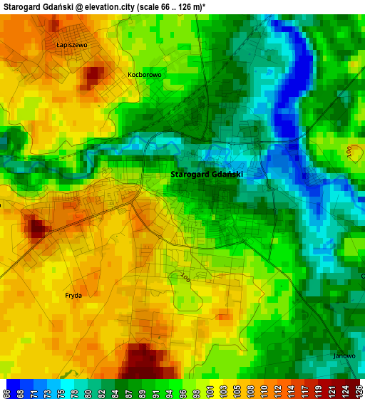
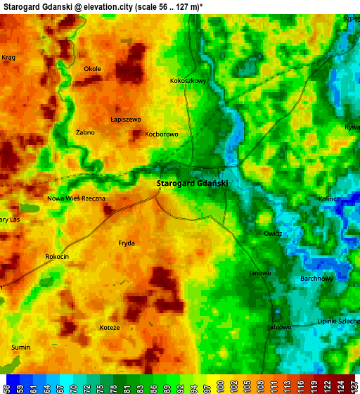
Below is the Elevation map of Starogard Gdański, which displays elevation range with different colors. Scale of the first map is from 66 to 126 m (217 to 413 ft) with average elevation of 95 meters (=312 ft) [note 1]
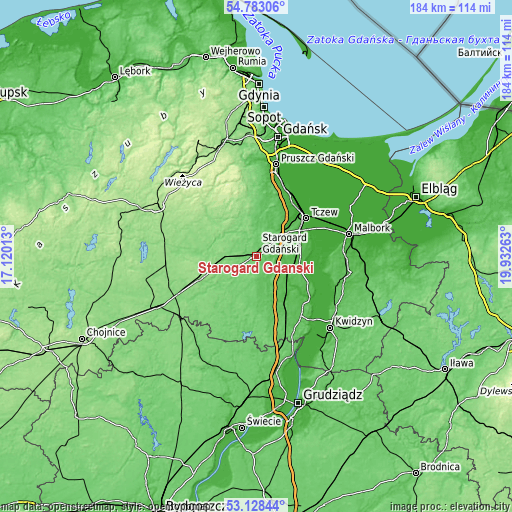
These maps also provides idea of topography and contour of this city, they are displayed at different zoom levels. More info about maps, scale and edge coordinates you can find below images.
| \ | Map #1 | Map #2 | Topo.Map |
| Scale [m] | 66..126 m | 56..127 m | × |
| Scale [ft] | 217..413 ft | 184..417 ft | × |
| Average | 95 m = 312 ft | 94.7 m = 311 ft | × |
| Width | 5.75 km = 3.6 mi | 11.5 km = 7.1 mi | 184 km = 114.3 mi |
| Height | 5.75 km = 3.6 mi | 11.5 km = 7.1 mi | 184 km = 114.3 mi |
| ↑Max Latitude | 53.989805° | 54.015633° | 54.78306° |
| Latitude at center | 53.96396° | 53.96396° | 53.96396° |
| ↓Min Latitude | 53.938099° | 53.912222° | 53.12844° |
| ← Min Longitude | 18.482435° | 18.438489° | 17.12013° |
| Longitude center | 18.52638° | 18.52638° | 18.52638° |
| →Max Longitude | 18.570325° | 18.614271° | 19.93263° |
Nearby cities:
Cities around Starogard Gdański sort by population:
• Tczew elevation 29 m
21.8 km,  48°
48°
• Pelplin 41 m
11.9 km,  109°
109°
• Skarszewy 112 m
12.9 km,  335°
335°
• Skórcz 84 m
18.9 km,  180°
180°
• Zblewo 115 m
13.8 km,  255°
255°
• Lubichowo 103 m
15 km,  213°
213°
• Kaliska 143 m
21.2 km,  252°
252°
• Subkowy 32 m
16.4 km,  74°
74°
• Stara Kiszewa 122 m
23.5 km,  277°
277°
• Trąbki Wielkie 103 m
23 km,  2°
2°
• Bobowo 66 m
9.1 km,  167°
167°
• Liniewo 149 m
23.2 km,  302°
302°
Multilingual:
 En español:
Starogard Gdański elevación 90 m.
 En France:
Starogard Gdański élévation 90 m.
 Auf Deutsch:
Starogard Gdański höhe über dem Meeresspiegel ist 90 m.
 На русском:
Старогард-Гданьски, Старогард-Гданьский высота над уровнем моря 90 м
Sources and notes:
- [note 1] Map square and city borders are not equal. Map elevation data is calculated only from area inside that square.
- [src 1] Elevation data from geonames database provided with same terms of usage.
- [src 2] The elevation map of Starogard Gdański is generated using elevation data from NASA's 3 arcsec (90m) resolution SRTM data.
- [src 3] Base (background) map © OpenStreetMap contributors tiles are generated by Geofabrik and OpenTopoMap.
Copyright & License:
This Starogard Gdański Elevation Map is licensed under CC BY-SA. You may reuse any part from this page, if you give a proper credit by linking to this URL:
 More info on terms of use page.