Pelplin elevation
Pelplin (Pomerania, Powiat tczewski), Poland elevation is 41 meters and Pelplin elevation in feet is 135 ft above sea level [src 1]. Pelplin is a populated place (feature code) with elevation that is 150 meters (492 ft) smaller than average city elevation in Poland.
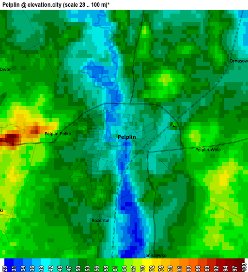
Below is the Elevation map of Pelplin, which displays elevation range with different colors. Scale of the first map is from 28 to 100 m (92 to 328 ft) with average elevation of 52.4 meters (=172 ft) [note 1]
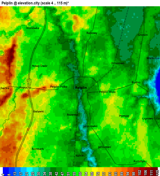
These maps also provides idea of topography and contour of this city, they are displayed at different zoom levels. More info about maps, scale and edge coordinates you can find below images.
| \ | Map #1 | Map #2 | Topo.Map |
| Scale [m] | 28..100 m | 4..115 m | × |
| Scale [ft] | 92..328 ft | 13..377 ft | × |
| Average | 52.4 m = 172 ft | 55.4 m = 182 ft | × |
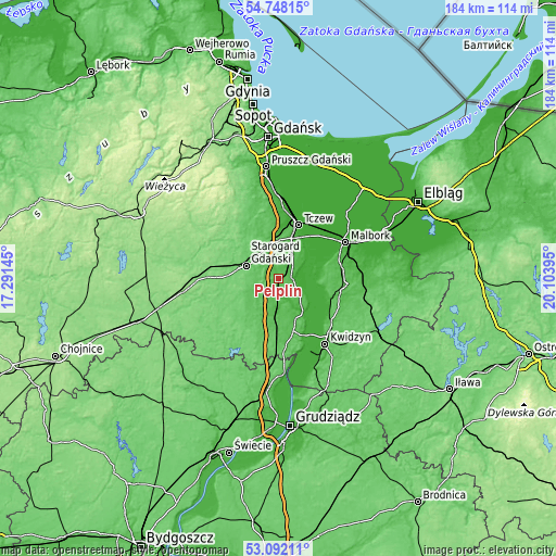
| Width | 5.75 km = 3.6 mi | 11.51 km = 7.2 mi | 184.1 km = 114.4 mi |
| Height | 5.75 km = 3.6 mi | 11.51 km = 7.2 mi | 184.1 km = 114.4 mi |
| ↑Max Latitude | 53.954207° | 53.980058° | 54.74815° |
| Latitude at center | 53.92834° | 53.92834° | 53.92834° |
| ↓Min Latitude | 53.902457° | 53.876558° | 53.09211° |
| ← Min Longitude | 18.653755° | 18.609809° | 17.29145° |
| Longitude center | 18.6977° | 18.6977° | 18.6977° |
| →Max Longitude | 18.741645° | 18.785591° | 20.10395° |
Nearby cities:
Cities around Pelplin sort by population:
• Tczew elevation 29 m
19 km,  16°
16°
• Starogard Gdański 90 m
11.9 km,  289°
289°
• Sztum 58 m
21.8 km,  92°
92°
• Gniew 35 m
13.1 km,  141°
141°
• Skórcz 84 m
18.7 km,  217°
217°
• Smętowo Graniczne 84 m
20.2 km,  182°
182°
• Ryjewo 19 m
19.6 km,  118°
118°
• Lubichowo 103 m
21.4 km,  246°
246°
• Subkowy 32 m
9.5 km,  29°
29°
• Lisewo Malborskie 5 m
20.6 km, 24°
• Bobowo 66 m
10.5 km,  241°
241°
• Miłoradz 5 m
17.3 km,  56°
56°
Multilingual:
 En español:
Pelplin elevación 41 m.
 En France:
Pelplin élévation 41 m.


Sources and notes:
- [note 1] Map square and city borders are not equal. Map elevation data is calculated only from area inside that square.
- [src 1] Elevation data from geonames database provided with same terms of usage.
- [src 2] The elevation map of Pelplin is generated using elevation data from NASA's 3 arcsec (90m) resolution SRTM data.
- [src 3] Base (background) map © OpenStreetMap contributors tiles are generated by Geofabrik and OpenTopoMap.
Copyright & License:
This Pelplin Elevation Map is licensed under CC BY-SA. You may reuse any part from this page, if you give a proper credit by linking to this URL:
 More info on terms of use page.