Smętowo Graniczne elevation
Smętowo Graniczne (Pomerania, Powiat starogardzki), Poland elevation is 84 meters and Smętowo Graniczne elevation in feet is 276 ft above sea level [src 1]. Smętowo Graniczne is a populated place (feature code) with elevation that is 107 meters (351 ft) smaller than average city elevation in Poland.
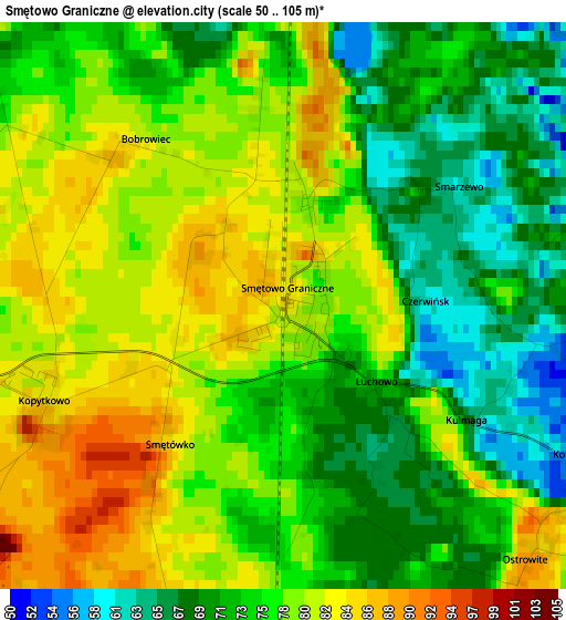
Below is the Elevation map of Smętowo Graniczne, which displays elevation range with different colors. Scale of the first map is from 50 to 105 m (164 to 344 ft) with average elevation of 75.8 meters (=249 ft) [note 1]
These maps also provides idea of topography and contour of this city, they are displayed at different zoom levels. More info about maps, scale and edge coordinates you can find below images.
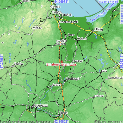
| \ | Map #1 | Topo.Map |
| Scale [m] | 50..105 m | × |
| Scale [ft] | 164..344 ft | × |
| Average | 75.8 m = 249 ft | × |
| Width | 5.78 km = 3.6 mi | 184.9 km = 114.9 mi |
| Height | 5.78 km = 3.6 mi | 184.9 km = 114.9 mi |
| ↑Max Latitude | 53.772359° | 54.56978° |
| Latitude at center | 53.74638° | 53.74638° |
| ↓Min Latitude | 53.720384° | 52.90652° |
| ← Min Longitude | 18.641915° | 17.27961° |
| Longitude center | 18.68586° | 18.68586° |
| →Max Longitude | 18.729805° | 20.09211° |
Nearby cities:
Cities around Smętowo Graniczne sort by population:
• Kwidzyn elevation 64 m
16.3 km,  98°
98°
• Pelplin 41 m
20.2 km,  2°
2°
• Gniew 35 m
13.4 km,  42°
42°
• Nowe 74 m
11.2 km,  165°
165°
• Skórcz 84 m
11.8 km,  296°
296°
• Ryjewo 19 m
21.1 km,  58°
58°
• Gardeja 84 m
22.8 km,  131°
131°
• Lubichowo 103 m
22.2 km, 301°
• Warlubie 72 m
18 km,  190°
190°
• Sadlinki 16 m
15 km, 126°
• Bobowo 66 m
17.5 km,  330°
330°
• Osiek 91 m
13.1 km,  258°
258°
Multilingual:
 En español:
Smętowo Graniczne elevación 84 m.
 En France:
Smętowo Graniczne élévation 84 m.
 Auf Deutsch:
Smętowo Graniczne höhe über dem Meeresspiegel ist 84 m.

Sources and notes:
- [note 1] Map square and city borders are not equal. Map elevation data is calculated only from area inside that square.
- [src 1] Elevation data from geonames database provided with same terms of usage.
- [src 2] The elevation map of Smętowo Graniczne is generated using elevation data from NASA's 3 arcsec (90m) resolution SRTM data.
- [src 3] Base (background) map © OpenStreetMap contributors tiles are generated by Geofabrik and OpenTopoMap.
Copyright & License:
This Smętowo Graniczne Elevation Map is licensed under CC BY-SA. You may reuse any part from this page, if you give a proper credit by linking to this URL:
 More info on terms of use page.