Olszanica elevation
Olszanica (Lower Silesia, Powiat złotoryjski), Poland elevation is 214 meters and Olszanica elevation in feet is 702 ft above sea level [src 1]. Olszanica is a populated place (feature code) with elevation that is 23 meters (75 ft) bigger than average city elevation in Poland.
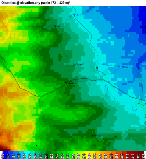
Below is the Elevation map of Olszanica, which displays elevation range with different colors. Scale of the first map is from 172 to 329 m (564 to 1079 ft) with average elevation of 223.4 meters (=733 ft) [note 1]
These maps also provides idea of topography and contour of this city, they are displayed at different zoom levels. More info about maps, scale and edge coordinates you can find below images.
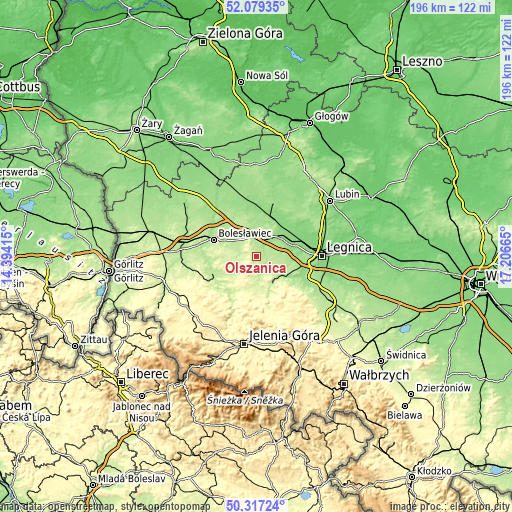
| \ | Map #1 | Topo.Map |
| Scale [m] | 172..329 m | × |
| Scale [ft] | 564..1079 ft | × |
| Average | 223.4 m = 733 ft | × |
| Width | 6.12 km = 3.8 mi | 195.9 km = 121.7 mi |
| Height | 6.12 km = 3.8 mi | 195.9 km = 121.7 mi |
| ↑Max Latitude | 51.234244° | 52.07935° |
| Latitude at center | 51.20672° | 51.20672° |
| ↓Min Latitude | 51.179179° | 50.31724° |
| ← Min Longitude | 15.756455° | 14.39415° |
| Longitude center | 15.8004° | 15.8004° |
| →Max Longitude | 15.844345° | 17.20665° |
Nearby cities:
Cities around Olszanica sort by population:
• Legnica elevation 121 m
25.2 km,  89°
89°
• Bolesławiec 197 m
17.3 km,  291°
291°
• Złotoryja 211 m
12.2 km,  137°
137°
• Chojnów 153 m
12.1 km,  51°
51°
• Lwówek Śląski 213 m
18.4 km,  234°
234°
• Chocianów 148 m
24.6 km,  16°
16°
• Świerzawa 267 m
22.5 km,  162°
162°
• Gromadka 148 m
17.3 km,  351°
351°
• Miłkowice 125 m
19.7 km,  73°
73°
• Wilków 274 m
15.6 km,  145°
145°
• Wleń 230 m
22.9 km,  202°
202°
• Zagrodno 182 m
4.8 km,  110°
110°
Multilingual:
 En español:
Olszanica elevación 214 m.
 En France:
Olszanica élévation 214 m.
 Auf Deutsch:
Olszanica höhe über dem Meeresspiegel ist 214 m.

Sources and notes:
- [note 1] Map square and city borders are not equal. Map elevation data is calculated only from area inside that square.
- [src 1] Elevation data from geonames database provided with same terms of usage.
- [src 2] The elevation map of Olszanica is generated using elevation data from NASA's 3 arcsec (90m) resolution SRTM data.
- [src 3] Base (background) map © OpenStreetMap contributors tiles are generated by Geofabrik and OpenTopoMap.
Copyright & License:
This Olszanica Elevation Map is licensed under CC BY-SA. You may reuse any part from this page, if you give a proper credit by linking to this URL:
 More info on terms of use page.