Sławków elevation
Sławków (Silesia, Powiat będziński), Poland elevation is 308 meters and Sławków elevation in feet is 1010 ft above sea level [src 1]. Sławków is a seat of a third-order administrative division (feature code) with elevation that is 117 meters (384 ft) bigger than average city elevation in Poland.
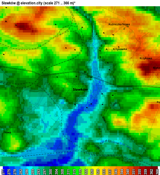
Below is the Elevation map of Sławków, which displays elevation range with different colors. Scale of the first map is from 271 to 366 m (889 to 1201 ft) with average elevation of 310.7 meters (=1019 ft) [note 1]
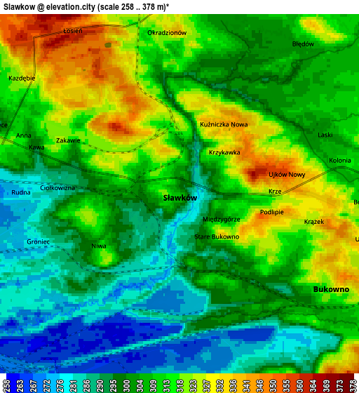
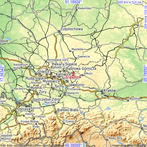
These maps also provides idea of topography and contour of this city, they are displayed at different zoom levels. More info about maps, scale and edge coordinates you can find below images.
| \ | Map #1 | Map #2 | Topo.Map |
| Scale [m] | 271..366 m | 258..378 m | × |
| Scale [ft] | 889..1201 ft | 846..1240 ft | × |
| Average | 310.7 m = 1019 ft | 305.5 m = 1002 ft | × |
| Width | 6.24 km = 3.9 mi | 12.48 km = 7.8 mi | 199.8 km = 124.1 mi |
| Height | 6.24 km = 3.9 mi | 12.48 km = 7.8 mi | 199.7 km = 124.1 mi |
| ↑Max Latitude | 50.327493° | 50.355539° | 51.18924° |
| Latitude at center | 50.29943° | 50.29943° | 50.29943° |
| ↓Min Latitude | 50.271351° | 50.243254° | 49.39265° |
| ← Min Longitude | 19.345725° | 19.301779° | 17.98342° |
| Longitude center | 19.38967° | 19.38967° | 19.38967° |
| →Max Longitude | 19.433615° | 19.477561° | 20.79592° |
Nearby cities:
Cities around Sławków sort by population:
• Dąbrowa Górnicza elevation 287 m
13.7 km,  286°
286°
• Jaworzno 318 m
13.3 km,  217°
217°
• Olkusz 366 m
12.6 km,  99°
99°
• Bukowno 314 m
6.3 km,  127°
127°
• Łazy 341 m
14.3 km,  1°
1°
• Klucze 352 m
12.9 km,  71°
71°
• Balin 315 m
14.6 km,  181°
181°
• Bolesław 312 m
6.5 km,  92°
92°
• Niegowonice 347 m
10.2 km,  13°
13°
• Myślachowice 403 m
14.3 km,  152°
152°
• Luszowice 318 m
14 km, 175°
• Chruszczobród 313 m
13.6 km,  340°
340°
Multilingual:
 En español:
Sławków elevación 308 m.
 En France:
Sławków élévation 308 m.


Sources and notes:
- [note 1] Map square and city borders are not equal. Map elevation data is calculated only from area inside that square.
- [src 1] Elevation data from geonames database provided with same terms of usage.
- [src 2] The elevation map of Sławków is generated using elevation data from NASA's 3 arcsec (90m) resolution SRTM data.
- [src 3] Base (background) map © OpenStreetMap contributors tiles are generated by Geofabrik and OpenTopoMap.
Copyright & License:
This Sławków Elevation Map is licensed under CC BY-SA. You may reuse any part from this page, if you give a proper credit by linking to this URL:
 More info on terms of use page.