Myślachowice elevation
Myślachowice (Lesser Poland, Powiat chrzanowski), Poland elevation is 403 meters and Myślachowice elevation in feet is 1322 ft above sea level [src 1]. Myślachowice is a populated place (feature code) with elevation that is 212 meters (696 ft) bigger than average city elevation in Poland.
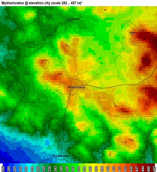
Below is the Elevation map of Myślachowice, which displays elevation range with different colors. Scale of the first map is from 282 to 457 m (925 to 1499 ft) with average elevation of 366.5 meters (=1202 ft) [note 1]
These maps also provides idea of topography and contour of this city, they are displayed at different zoom levels. More info about maps, scale and edge coordinates you can find below images.
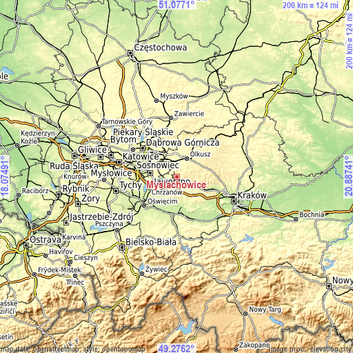
| \ | Map #1 | Topo.Map |
| Scale [m] | 282..457 m | × |
| Scale [ft] | 925..1499 ft | × |
| Average | 366.5 m = 1202 ft | × |
| Width | 6.26 km = 3.9 mi | 200.2 km = 124.4 mi |
| Height | 6.26 km = 3.9 mi | 200.2 km = 124.4 mi |
| ↑Max Latitude | 50.21327° | 51.0771° |
| Latitude at center | 50.18514° | 50.18514° |
| ↓Min Latitude | 50.156993° | 49.2762° |
| ← Min Longitude | 19.437215° | 18.07491° |
| Longitude center | 19.48116° | 19.48116° |
| →Max Longitude | 19.525105° | 20.88741° |
Nearby cities:
Cities around Myślachowice sort by population:
• Chrzanów elevation 273 m
7.9 km,  225°
225°
• Trzebinia 314 m
3 km,  195°
195°
• Bukowno 314 m
9 km,  350°
350°
• Płaza 368 m
9.6 km,  187°
187°
• Balin 315 m
7.2 km,  254°
254°
• Wola Filipowska 286 m
9 km,  128°
128°
• Filipowice 319 m
6.9 km,  118°
118°
• Bolęcin 301 m
7.5 km,  180°
180°
• Luszowice 318 m
5.6 km,  257°
257°
• Nowa Góra 420 m
7.9 km,  99°
99°
• Psary 378 m
3.7 km,  112°
112°
• Ostrężnica 456 m
6.4 km,  82°
82°
Multilingual:
 En español:
Myślachowice elevación 403 m.
 En France:
Myślachowice élévation 403 m.
 Auf Deutsch:
Myślachowice höhe über dem Meeresspiegel ist 403 m.

Sources and notes:
- [note 1] Map square and city borders are not equal. Map elevation data is calculated only from area inside that square.
- [src 1] Elevation data from geonames database provided with same terms of usage.
- [src 2] The elevation map of Myślachowice is generated using elevation data from NASA's 3 arcsec (90m) resolution SRTM data.
- [src 3] Base (background) map © OpenStreetMap contributors tiles are generated by Geofabrik and OpenTopoMap.
Copyright & License:
This Myślachowice Elevation Map is licensed under CC BY-SA. You may reuse any part from this page, if you give a proper credit by linking to this URL:
 More info on terms of use page.