Ostrężnica elevation
Ostrężnica (Lesser Poland, Powiat krakowski), Poland elevation is 456 meters and Ostrężnica elevation in feet is 1496 ft above sea level [src 1]. Ostrężnica is a populated place (feature code) with elevation that is 265 meters (869 ft) bigger than average city elevation in Poland.
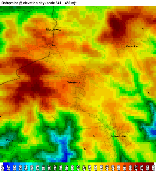
Below is the Elevation map of Ostrężnica, which displays elevation range with different colors. Scale of the first map is from 341 to 489 m (1119 to 1604 ft) with average elevation of 432.6 meters (=1419 ft) [note 1]
These maps also provides idea of topography and contour of this city, they are displayed at different zoom levels. More info about maps, scale and edge coordinates you can find below images.
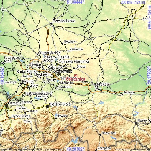
| \ | Map #1 | Topo.Map |
| Scale [m] | 341..489 m | × |
| Scale [ft] | 1119..1604 ft | × |
| Average | 432.6 m = 1419 ft | × |
| Width | 6.26 km = 3.9 mi | 200.2 km = 124.4 mi |
| Height | 6.26 km = 3.9 mi | 200.2 km = 124.4 mi |
| ↑Max Latitude | 50.220746° | 51.08444° |
| Latitude at center | 50.19262° | 50.19262° |
| ↓Min Latitude | 50.164478° | 49.28382° |
| ← Min Longitude | 19.526825° | 18.16452° |
| Longitude center | 19.57077° | 19.57077° |
| →Max Longitude | 19.614715° | 20.97702° |
Nearby cities:
Cities around Ostrężnica sort by population:
• Trzebinia elevation 314 m
8.1 km,  242°
242°
• Krzeszowice 271 m
7.1 km,  141°
141°
• Tenczynek 263 m
8.6 km,  159°
159°
• Wola Filipowska 286 m
6.5 km,  174°
174°
• Filipowice 319 m
4.1 km,  184°
184°
• Myślachowice 403 m
6.4 km,  262°
262°
• Nowa Góra 420 m
2.6 km,  146°
146°
• Racławice 361 m
7.6 km,  89°
89°
• Psary 378 m
3.7 km,  232°
232°
• Osiek 432 m
6 km,  20°
20°
• Gorenice 442 m
3.9 km,  64°
64°
• Miękinia 360 m
4.9 km, 146°
Multilingual:
 En español:
Ostrężnica elevación 456 m.
 En France:
Ostrężnica élévation 456 m.
 Auf Deutsch:
Ostrężnica höhe über dem Meeresspiegel ist 456 m.

Sources and notes:
- [note 1] Map square and city borders are not equal. Map elevation data is calculated only from area inside that square.
- [src 1] Elevation data from geonames database provided with same terms of usage.
- [src 2] The elevation map of Ostrężnica is generated using elevation data from NASA's 3 arcsec (90m) resolution SRTM data.
- [src 3] Base (background) map © OpenStreetMap contributors tiles are generated by Geofabrik and OpenTopoMap.
Copyright & License:
This Ostrężnica Elevation Map is licensed under CC BY-SA. You may reuse any part from this page, if you give a proper credit by linking to this URL:
 More info on terms of use page.