Balin elevation
Balin (Lesser Poland, Powiat chrzanowski), Poland elevation is 315 meters and Balin elevation in feet is 1033 ft above sea level [src 1]. Balin is a section of populated place (feature code) with elevation that is 124 meters (407 ft) bigger than average city elevation in Poland.
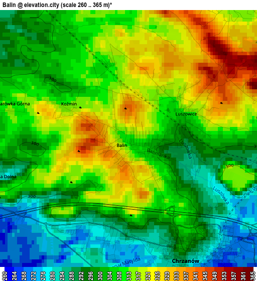
Below is the Elevation map of Balin, which displays elevation range with different colors. Scale of the first map is from 260 to 365 m (853 to 1198 ft) with average elevation of 306.5 meters (=1006 ft) [note 1]
These maps also provides idea of topography and contour of this city, they are displayed at different zoom levels. More info about maps, scale and edge coordinates you can find below images.
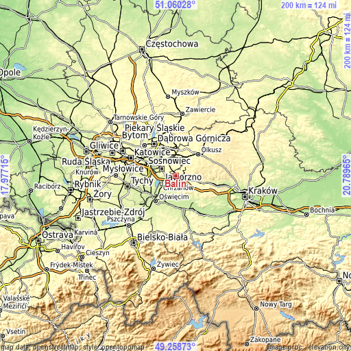
| \ | Map #1 | Topo.Map |
| Scale [m] | 260..365 m | × |
| Scale [ft] | 853..1198 ft | × |
| Average | 306.5 m = 1006 ft | × |
| Width | 6.26 km = 3.9 mi | 200.3 km = 124.5 mi |
| Height | 6.26 km = 3.9 mi | 200.3 km = 124.5 mi |
| ↑Max Latitude | 50.19613° | 51.06028° |
| Latitude at center | 50.16799° | 50.16799° |
| ↓Min Latitude | 50.139833° | 49.25873° |
| ← Min Longitude | 19.339455° | 17.97715° |
| Longitude center | 19.3834° | 19.3834° |
| →Max Longitude | 19.427345° | 20.78965° |
Nearby cities:
Cities around Balin sort by population:
• Jaworzno elevation 318 m
8.8 km,  298°
298°
• Chrzanów 273 m
3.9 km,  159°
159°
• Trzebinia 314 m
6.2 km,  98°
98°
• Libiąż 285 m
8.6 km,  214°
214°
• Płaza 368 m
9.5 km,  142°
142°
• Żarki 257 m
9.8 km,  193°
193°
• Zagórze 293 m
8.3 km,  170°
170°
• Myślachowice 403 m
7.2 km,  74°
74°
• Bolęcin 301 m
8.9 km,  128°
128°
• Luszowice 318 m
1.6 km, 65°
• Psary 378 m
10.4 km,  87°
87°
• Pogorzyce 358 m
7.9 km, 159°
Multilingual:
 En español:
Balin elevación 315 m.
 En France:
Balin élévation 315 m.


Sources and notes:
- [note 1] Map square and city borders are not equal. Map elevation data is calculated only from area inside that square.
- [src 1] Elevation data from geonames database provided with same terms of usage.
- [src 2] The elevation map of Balin is generated using elevation data from NASA's 3 arcsec (90m) resolution SRTM data.
- [src 3] Base (background) map © OpenStreetMap contributors tiles are generated by Geofabrik and OpenTopoMap.
Copyright & License:
This Balin Elevation Map is licensed under CC BY-SA. You may reuse any part from this page, if you give a proper credit by linking to this URL:
 More info on terms of use page.