Łazy elevation
Łazy (Silesia, Powiat zawierciański), Poland elevation is 341 meters and Łazy elevation in feet is 1119 ft above sea level [src 1]. Łazy is a populated place (feature code) with elevation that is 150 meters (492 ft) bigger than average city elevation in Poland.
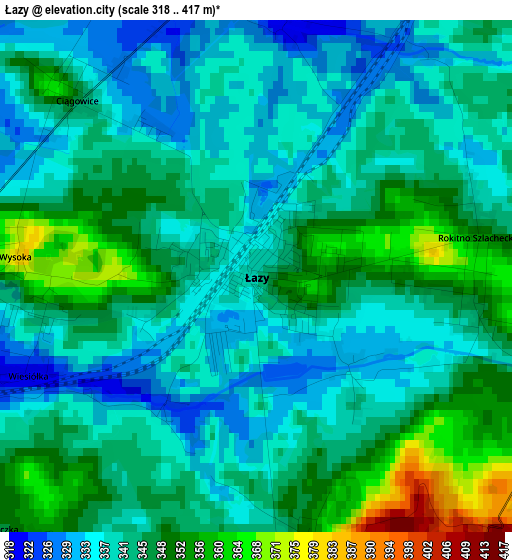
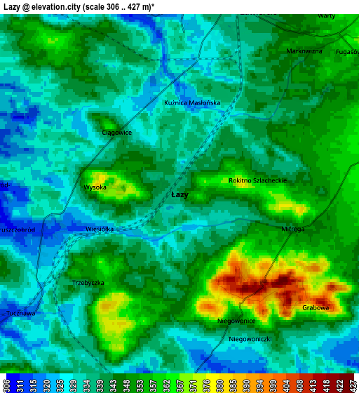
Below is the Elevation map of Łazy, which displays elevation range with different colors. Scale of the first map is from 318 to 417 m (1043 to 1368 ft) with average elevation of 343 meters (=1125 ft) [note 1]
These maps also provides idea of topography and contour of this city, they are displayed at different zoom levels. More info about maps, scale and edge coordinates you can find below images.
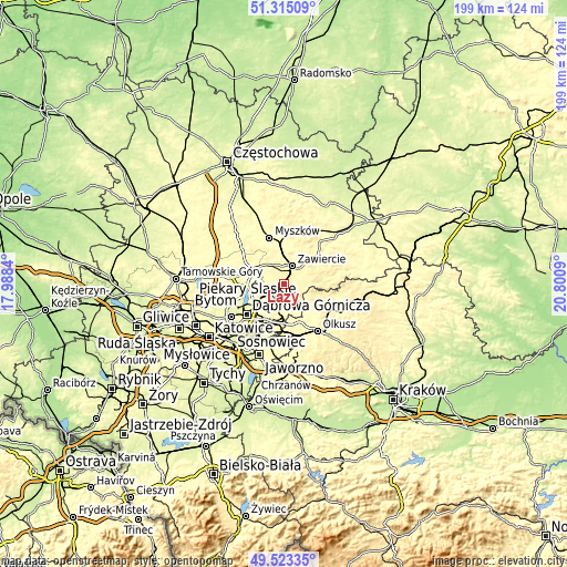
| \ | Map #1 | Map #2 | Topo.Map |
| Scale [m] | 318..417 m | 306..427 m | × |
| Scale [ft] | 1043..1368 ft | 1004..1401 ft | × |
| Average | 343 m = 1125 ft | 341.7 m = 1121 ft | × |
| Width | 6.23 km = 3.9 mi | 12.45 km = 7.7 mi | 199.2 km = 123.8 mi |
| Height | 6.23 km = 3.9 mi | 12.45 km = 7.7 mi | 199.2 km = 123.8 mi |
| ↑Max Latitude | 50.455677° | 50.483648° | 51.31509° |
| Latitude at center | 50.42769° | 50.42769° | 50.42769° |
| ↓Min Latitude | 50.399686° | 50.371666° | 49.52335° |
| ← Min Longitude | 19.350705° | 19.306759° | 17.9884° |
| Longitude center | 19.39465° | 19.39465° | 19.39465° |
| →Max Longitude | 19.438595° | 19.482541° | 20.8009° |
Nearby cities:
Cities around Łazy sort by population:
• Zawiercie elevation 332 m
6.8 km,  13°
13°
• Poręba 312 m
7.8 km,  329°
329°
• Sławków 308 m
14.3 km,  181°
181°
• Klucze 352 m
15.7 km,  130°
130°
• Siewierz 299 m
12.4 km,  290°
290°
• Ogrodzieniec 392 m
9.3 km,  73°
73°
• Niegowonice 347 m
4.7 km,  155°
155°
• Chruszczobród 313 m
5 km,  253°
253°
• Rudniki 354 m
10.7 km, 13°
• Włodowice 388 m
14.8 km,  15°
15°
• Wysoka 381 m
2.9 km,  274°
274°
• Rokitno Szlacheckie 354 m
2.8 km,  80°
80°
Multilingual:
 En español:
Łazy elevación 341 m.
 En France:
Łazy élévation 341 m.


Sources and notes:
- [note 1] Map square and city borders are not equal. Map elevation data is calculated only from area inside that square.
- [src 1] Elevation data from geonames database provided with same terms of usage.
- [src 2] The elevation map of Łazy is generated using elevation data from NASA's 3 arcsec (90m) resolution SRTM data.
- [src 3] Base (background) map © OpenStreetMap contributors tiles are generated by Geofabrik and OpenTopoMap.
Copyright & License:
This Łazy Elevation Map is licensed under CC BY-SA. You may reuse any part from this page, if you give a proper credit by linking to this URL:
 More info on terms of use page.