Suszec elevation
Suszec (Silesia, Powiat pszczyński), Poland elevation is 265 meters and Suszec elevation in feet is 869 ft above sea level [src 1]. Suszec is a seat of a third-order administrative division (feature code) with elevation that is 74 meters (243 ft) bigger than average city elevation in Poland.
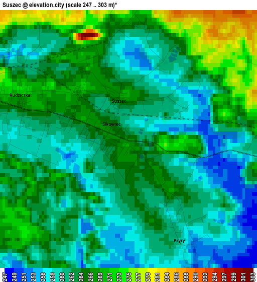
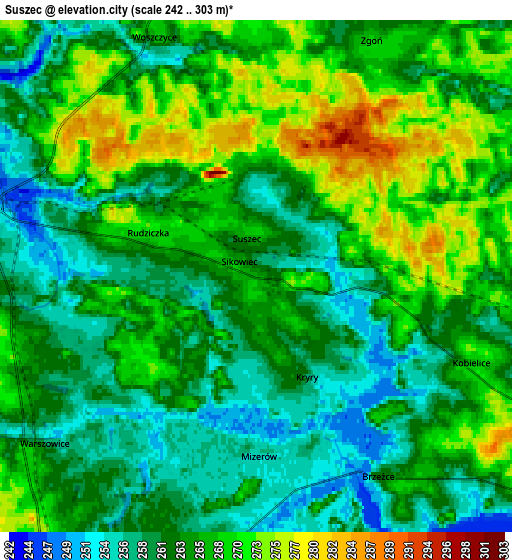
Below is the Elevation map of Suszec, which displays elevation range with different colors. Scale of the first map is from 247 to 303 m (810 to 994 ft) with average elevation of 263.6 meters (=865 ft) [note 1]
These maps also provides idea of topography and contour of this city, they are displayed at different zoom levels. More info about maps, scale and edge coordinates you can find below images.
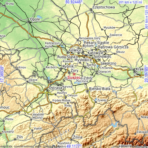
| \ | Map #1 | Map #2 | Topo.Map |
| Scale [m] | 247..303 m | 242..303 m | × |
| Scale [ft] | 810..994 ft | 794..994 ft | × |
| Average | 263.6 m = 865 ft | 264.4 m = 867 ft | × |
| Width | 6.28 km = 3.9 mi | 12.56 km = 7.8 mi | 200.9 km = 124.8 mi |
| Height | 6.28 km = 3.9 mi | 12.56 km = 7.8 mi | 200.9 km = 124.8 mi |
| ↑Max Latitude | 50.057802° | 50.086007° | 50.92446° |
| Latitude at center | 50.02958° | 50.02958° | 50.02958° |
| ↓Min Latitude | 50.001342° | 49.973087° | 49.1177° |
| ← Min Longitude | 18.747655° | 18.703709° | 17.38535° |
| Longitude center | 18.7916° | 18.7916° | 18.7916° |
| →Max Longitude | 18.835545° | 18.879491° | 20.19785° |
Nearby cities:
Cities around Suszec sort by population:
• Żory elevation 251 m
6.7 km,  284°
284°
• Pawłowice 264 m
9.2 km,  214°
214°
• Kobiór 248 m
10.8 km,  71°
71°
• Piasek 252 m
11.4 km,  100°
100°
• Gostyń 254 m
10.6 km,  37°
37°
• Studzionka 256 m
7.6 km,  190°
190°
• Czarków 252 m
8.3 km, 98°
• Gardawice 261 m
9.7 km,  3°
3°
• Radostowice 267 m
7 km,  114°
114°
• Kryry 267 m
1.8 km,  144°
144°
• Rudziczka 268 m
2.2 km,  289°
289°
• Krzyżowice 253 m
9.8 km,  239°
239°
Multilingual:
 En español:
Suszec elevación 265 m.
 En France:
Suszec élévation 265 m.


Sources and notes:
- [note 1] Map square and city borders are not equal. Map elevation data is calculated only from area inside that square.
- [src 1] Elevation data from geonames database provided with same terms of usage.
- [src 2] The elevation map of Suszec is generated using elevation data from NASA's 3 arcsec (90m) resolution SRTM data.
- [src 3] Base (background) map © OpenStreetMap contributors tiles are generated by Geofabrik and OpenTopoMap.
Copyright & License:
This Suszec Elevation Map is licensed under CC BY-SA. You may reuse any part from this page, if you give a proper credit by linking to this URL:
 More info on terms of use page.