Węgliniec elevation
Węgliniec (Lower Silesia, Powiat zgorzelecki), Poland elevation is 192 meters and Węgliniec elevation in feet is 630 ft above sea level [src 1]. Węgliniec is a seat of a third-order administrative division (feature code) with elevation that is 1 meters (3 ft) bigger than average city elevation in Poland.
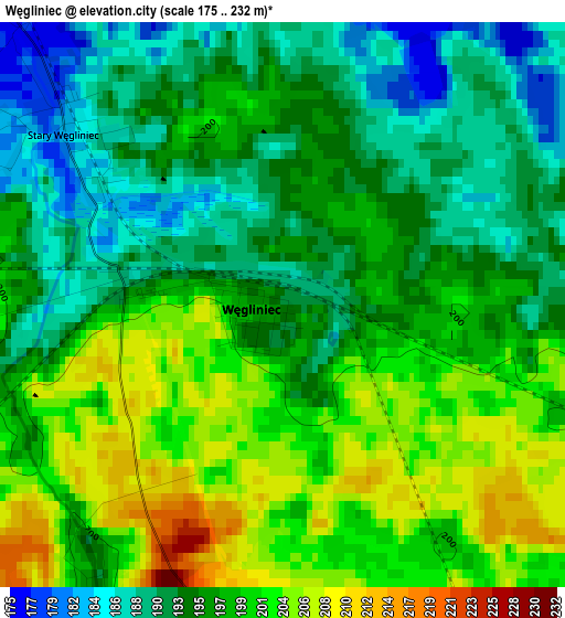
Below is the Elevation map of Węgliniec, which displays elevation range with different colors. Scale of the first map is from 175 to 232 m (574 to 761 ft) with average elevation of 196.6 meters (=645 ft) [note 1]
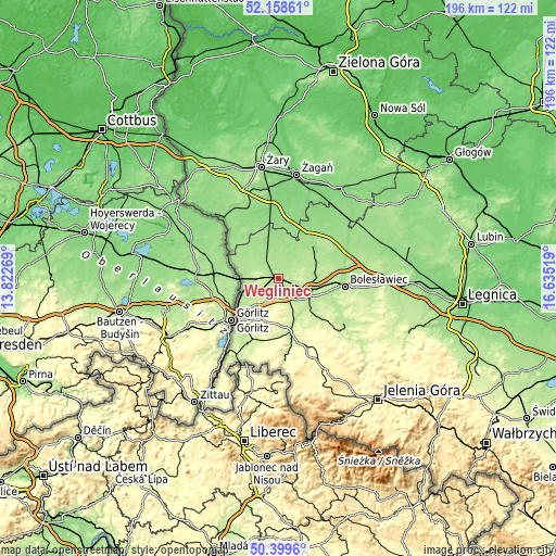
These maps also provides idea of topography and contour of this city, they are displayed at different zoom levels. More info about maps, scale and edge coordinates you can find below images.
| \ | Map #1 | Topo.Map |
| Scale [m] | 175..232 m | × |
| Scale [ft] | 574..761 ft | × |
| Average | 196.6 m = 645 ft | × |
| Width | 6.11 km = 3.8 mi | 195.6 km = 121.5 mi |
| Height | 6.11 km = 3.8 mi | 195.6 km = 121.5 mi |
| ↑Max Latitude | 51.315006° | 52.15861° |
| Latitude at center | 51.28753° | 51.28753° |
| ↓Min Latitude | 51.260038° | 50.3996° |
| ← Min Longitude | 15.184995° | 13.82269° |
| Longitude center | 15.22894° | 15.22894° |
| →Max Longitude | 15.272885° | 16.63519° |
Nearby cities:
Cities around Węgliniec sort by population:
• Bolesławiec elevation 197 m
23.8 km,  96°
96°
• Zgorzelec 216 m
21.7 km,  225°
225°
• Lubań 221 m
19.1 km,  167°
167°
• Pieńsk 186 m
13.4 km,  251°
251°
• Olszyna 245 m
26.5 km,  157°
157°
• Iłowa 126 m
23.8 km,  355°
355°
• Nowogrodziec 207 m
15.6 km,  130°
130°
• Gozdnica 150 m
18.9 km,  331°
331°
• Sulików 219 m
26 km,  205°
205°
• Siekierczyn 260 m
18.5 km,  187°
187°
• Pisarzowice 267 m
15.9 km,  179°
179°
• Łagów 196 m
19.3 km,  221°
221°
Multilingual:
 En español:
Węgliniec elevación 192 m.
 En France:
Węgliniec élévation 192 m.
 Auf Deutsch:
Węgliniec höhe über dem Meeresspiegel ist 192 m.

Sources and notes:
- [note 1] Map square and city borders are not equal. Map elevation data is calculated only from area inside that square.
- [src 1] Elevation data from geonames database provided with same terms of usage.
- [src 2] The elevation map of Węgliniec is generated using elevation data from NASA's 3 arcsec (90m) resolution SRTM data.
- [src 3] Base (background) map © OpenStreetMap contributors tiles are generated by Geofabrik and OpenTopoMap.
Copyright & License:
This Węgliniec Elevation Map is licensed under CC BY-SA. You may reuse any part from this page, if you give a proper credit by linking to this URL:
 More info on terms of use page.