Bat Khela elevation
Bat Khela (Khyber Pakhtunkhwa), Pakistan elevation is 673 meters and Bat Khela elevation in feet is 2208 ft above sea level [src 1]. Bat Khela is a populated place (feature code) with elevation that is 327 meters (1073 ft) bigger than average city elevation in Pakistan.
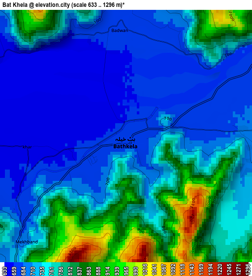
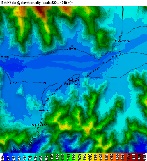
Below is the Elevation map of Bat Khela, which displays elevation range with different colors. Scale of the first map is from 633 to 1296 m (2077 to 4252 ft) with average elevation of 747.8 meters (=2453 ft) [note 1]
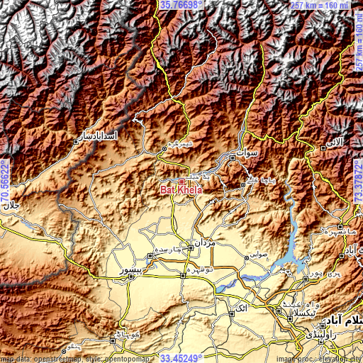
These maps also provides idea of topography and contour of this city, they are displayed at different zoom levels. More info about maps, scale and edge coordinates you can find below images.
| \ | Map #1 | Map #2 | Topo.Map |
| Scale [m] | 633..1296 m | 520..1919 m | × |
| Scale [ft] | 2077..4252 ft | 1706..6296 ft | × |
| Average | 747.8 m = 2453 ft | 825.5 m = 2708 ft | × |
| Width | 8.04 km = 5 mi | 16.08 km = 10 mi | 257.3 km = 159.9 mi |
| Height | 8.04 km = 5 mi | 16.08 km = 10 mi | 257.3 km = 159.9 mi |
| ↑Max Latitude | 34.653957° | 34.690099° | 35.76698° |
| Latitude at center | 34.6178° | 34.6178° | 34.6178° |
| ↓Min Latitude | 34.581627° | 34.545438° | 33.45249° |
| ← Min Longitude | 71.928525° | 71.884579° | 70.56622° |
| Longitude center | 71.97247° | 71.97247° | 71.97247° |
| →Max Longitude | 72.016415° | 72.060361° | 73.37872° |
Nearby cities:
Cities around Bat Khela sort by population:
• Mardan elevation 311 m
47.2 km,  171°
171°
• Mingora 939 m
39.9 km,  63°
63°
• Charsadda 301 m
56.4 km,  202°
202°
• Shabqadar 335 m
58.9 km,  220°
220°
• Tangi 358 m
45.9 km, 219°
• Utmanzai 304 m
51.5 km, 201°
• Kakad Wari Dir Upper 1409 m
43.3 km,  12°
12°
• Noorabad 331 m
40.7 km,  180°
180°
• Daggar 719 m
48.4 km,  104°
104°
• Saidu Sharif 957 m
37.8 km,  67°
67°
• Timargara 778 m
26 km,  333°
333°
• Malakand 844 m
7 km,  213°
213°
Multilingual:
 En español:
Bat Khela elevación 673 m.
 En France:
Bat Khela élévation 673 m.
 Auf Deutsch:
Bat Khela höhe über dem Meeresspiegel ist 673 m.

Sources and notes:
- [note 1] Map square and city borders are not equal. Map elevation data is calculated only from area inside that square.
- [src 1] Elevation data from geonames database provided with same terms of usage.
- [src 2] The elevation map of Bat Khela is generated using elevation data from NASA's 3 arcsec (90m) resolution SRTM data.
- [src 3] Base (background) map © OpenStreetMap contributors tiles are generated by Geofabrik and OpenTopoMap.
Copyright & License:
This Bat Khela Elevation Map is licensed under CC BY-SA. You may reuse any part from this page, if you give a proper credit by linking to this URL:
 More info on terms of use page.