Mingora elevation
Mingora (Khyber Pakhtunkhwa), Pakistan elevation is 939 meters and Mingora elevation in feet is 3081 ft above sea level [src 1]. Mingora is a populated place (feature code) with elevation that is 593 meters (1946 ft) bigger than average city elevation in Pakistan.
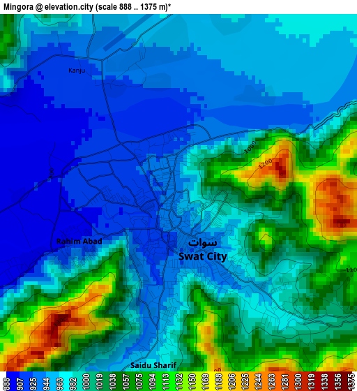
Below is the Elevation map of Mingora, which displays elevation range with different colors. Scale of the first map is from 888 to 1375 m (2913 to 4511 ft) with average elevation of 992 meters (=3255 ft) [note 1]
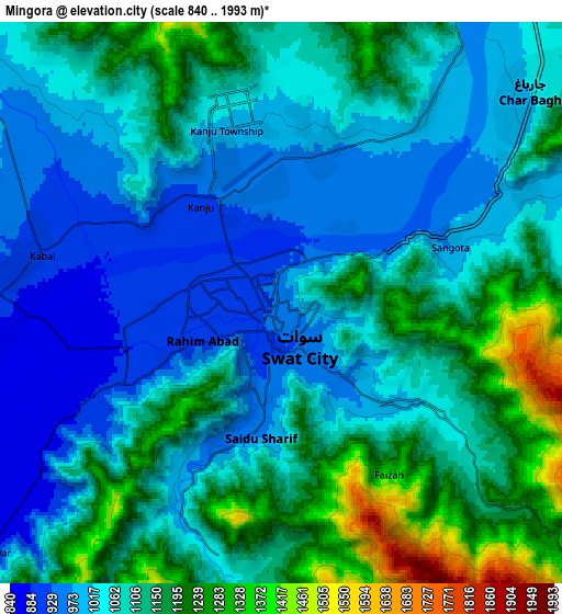
These maps also provides idea of topography and contour of this city, they are displayed at different zoom levels. More info about maps, scale and edge coordinates you can find below images.
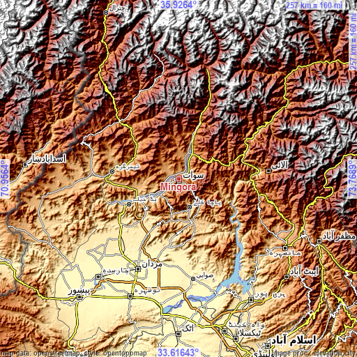
| \ | Map #1 | Map #2 | Topo.Map |
| Scale [m] | 888..1375 m | 840..1993 m | × |
| Scale [ft] | 2913..4511 ft | 2756..6539 ft | × |
| Average | 992 m = 3255 ft | 1091.1 m = 3580 ft | × |
| Width | 8.03 km = 5 mi | 16.05 km = 10 mi | 256.8 km = 159.6 mi |
| Height | 8.03 km = 5 mi | 16.05 km = 10 mi | 256.8 km = 159.6 mi |
| ↑Max Latitude | 34.815587° | 34.851658° | 35.9264° |
| Latitude at center | 34.7795° | 34.7795° | 34.7795° |
| ↓Min Latitude | 34.743397° | 34.707279° | 33.61643° |
| ← Min Longitude | 72.318705° | 72.274759° | 70.9564° |
| Longitude center | 72.36265° | 72.36265° | 72.36265° |
| →Max Longitude | 72.406595° | 72.450541° | 73.7689° |
Nearby cities:
Cities around Mingora sort by population:
• Battagram elevation 1031 m
61.4 km,  100°
100°
• Mardan 311 m
70.7 km,  203°
203°
• Bat Khela 673 m
39.9 km,  243°
243°
• Upper Dir 1407 m
65 km,  317°
317°
• Shingli Bala 1041 m
58 km, 101°
• Kakad Wari Dir Upper 1409 m
35.9 km,  312°
312°
• Noorabad 331 m
69 km,  211°
211°
• Timargara 778 m
47.6 km,  276°
276°
• Malakand 844 m
46.1 km, 238°
• Daggar 719 m
31.9 km,  159°
159°
• Alpurai 1451 m
29.2 km,  57°
57°
• Saidu Sharif 957 m
3.7 km,  189°
189°
Multilingual:
 En español:
Mingora elevación 939 m.
 En France:
Mingora élévation 939 m.


Sources and notes:
- [note 1] Map square and city borders are not equal. Map elevation data is calculated only from area inside that square.
- [src 1] Elevation data from geonames database provided with same terms of usage.
- [src 2] The elevation map of Mingora is generated using elevation data from NASA's 3 arcsec (90m) resolution SRTM data.
- [src 3] Base (background) map © OpenStreetMap contributors tiles are generated by Geofabrik and OpenTopoMap.
Copyright & License:
This Mingora Elevation Map is licensed under CC BY-SA. You may reuse any part from this page, if you give a proper credit by linking to this URL:
 More info on terms of use page.