Bhakkar elevation
Bhakkar (Punjab), Pakistan elevation is 171 meters and Bhakkar elevation in feet is 561 ft above sea level [src 1]. Bhakkar is a seat of a second-order administrative division (feature code) with elevation that is 175 meters (574 ft) smaller than average city elevation in Pakistan.
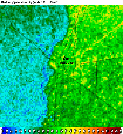
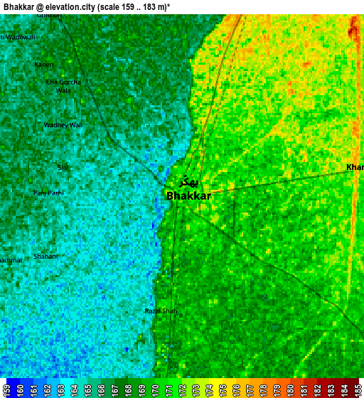
Below is the Elevation map of Bhakkar, which displays elevation range with different colors. Scale of the first map is from 159 to 175 m (522 to 574 ft) with average elevation of 167.5 meters (=550 ft) [note 1]
These maps also provides idea of topography and contour of this city, they are displayed at different zoom levels. More info about maps, scale and edge coordinates you can find below images.
| \ | Map #1 | Map #2 | Topo.Map |
| Scale [m] | 159..175 m | 159..183 m | × |
| Scale [ft] | 522..574 ft | 522..600 ft | × |
| Average | 167.5 m = 550 ft | 167.9 m = 551 ft | × |
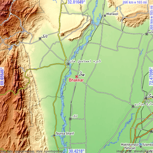
| Width | 8.32 km = 5.2 mi | 16.64 km = 10.3 mi | 266.3 km = 165.5 mi |
| Height | 8.32 km = 5.2 mi | 16.64 km = 10.3 mi | 266.3 km = 165.5 mi |
| ↑Max Latitude | 31.664261° | 31.701657° | 32.81649° |
| Latitude at center | 31.62685° | 31.62685° | 31.62685° |
| ↓Min Latitude | 31.589424° | 31.551983° | 30.4218° |
| ← Min Longitude | 71.020765° | 70.976819° | 69.65846° |
| Longitude center | 71.06471° | 71.06471° | 71.06471° |
| →Max Longitude | 71.108655° | 71.152601° | 72.47096° |
Nearby cities:
Cities around Bhakkar sort by population:
• Dera Ismail Khan elevation 177 m
27.5 km,  325°
325°
• Layyah 151 m
75 km,  189°
189°
• Shorkot 182 m
36.1 km, 330°
• Dullewala 183 m
42 km,  56°
56°
• Karor 157 m
46 km, 193°
• Kalur Kot 191 m
61.7 km,  17°
17°
• Kulachi 218 m
66.4 km,  300°
300°
• Chak Two Hundred Forty-nine Thal Development Authority 156 m
51.7 km,  165°
165°
• Paharpur 182 m
53.9 km,  350°
350°
• Harnoli 194 m
85.9 km,  32°
32°
• Darya Khan 176 m
17.9 km,  11°
11°
• Mankera 163 m
44.5 km,  126°
126°
Multilingual:
 En español:
Bhakkar elevación 171 m.
 En France:
Bhakkar élévation 171 m.


Sources and notes:
- [note 1] Map square and city borders are not equal. Map elevation data is calculated only from area inside that square.
- [src 1] Elevation data from geonames database provided with same terms of usage.
- [src 2] The elevation map of Bhakkar is generated using elevation data from NASA's 3 arcsec (90m) resolution SRTM data.
- [src 3] Base (background) map © OpenStreetMap contributors tiles are generated by Geofabrik and OpenTopoMap.
Copyright & License:
This Bhakkar Elevation Map is licensed under CC BY-SA. You may reuse any part from this page, if you give a proper credit by linking to this URL:
 More info on terms of use page.