Dera Ghazi Khan elevation
Dera Ghazi Khan (Punjab), Pakistan elevation is 122 meters and Dera Ghazi Khan elevation in feet is 400 ft above sea level [src 1]. Dera Ghazi Khan is a seat of a second-order administrative division (feature code) with elevation that is 224 meters (735 ft) smaller than average city elevation in Pakistan.
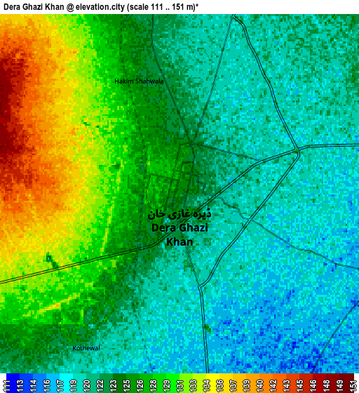
Below is the Elevation map of Dera Ghazi Khan, which displays elevation range with different colors. Scale of the first map is from 115 to 136 m (377 to 446 ft) with average elevation of 123.6 meters (=406 ft) [note 1]
These maps also provides idea of topography and contour of this city, they are displayed at different zoom levels. More info about maps, scale and edge coordinates you can find below images.

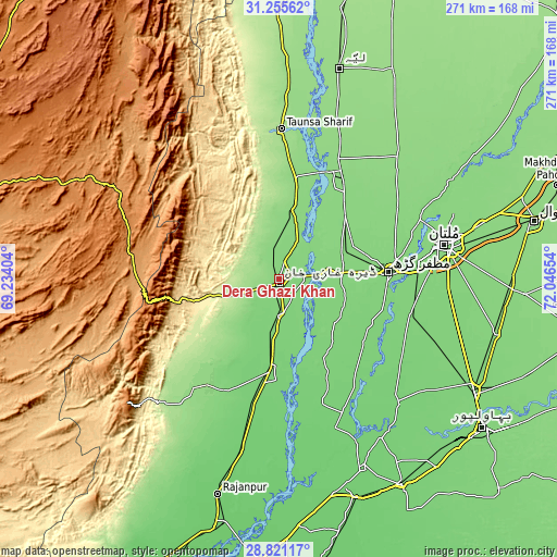
| \ | Map #1 | Map #2 | Topo.Map |
| Scale [m] | 115..136 m | 111..151 m | × |
| Scale [ft] | 377..446 ft | 364..495 ft | × |
| Average | 123.6 m = 406 ft | 124.4 m = 408 ft | × |
| Width | 8.46 km = 5.3 mi | 16.92 km = 10.5 mi | 270.7 km = 168.2 mi |
| Height | 8.46 km = 5.3 mi | 16.92 km = 10.5 mi | 270.7 km = 168.2 mi |
| ↑Max Latitude | 30.083903° | 30.121921° | 31.25562° |
| Latitude at center | 30.04587° | 30.04587° | 30.04587° |
| ↓Min Latitude | 30.007823° | 29.96976° | 28.82117° |
| ← Min Longitude | 70.596345° | 70.552399° | 69.23404° |
| Longitude center | 70.64029° | 70.64029° | 70.64029° |
| →Max Longitude | 70.684235° | 70.728181° | 72.04654° |
Nearby cities:
Cities around Dera Ghazi Khan sort by population:
• Muzaffargarh elevation 120 m
53.3 km,  86°
86°
• Kot Addu 136 m
56.6 km,  33°
33°
• Shujaabad 123 m
65.5 km,  106°
106°
• Jampur 107 m
45.1 km,  185°
185°
• Jatoi Shimali 106 m
61.9 km,  161°
161°
• Taunsa 175 m
73.1 km,  0°
0°
• Alipur 107 m
78.3 km, 160°
• Khangarh 120 m
52.2 km, 106°
• Dajal 124 m
60 km,  205°
205°
• Shahr Sultan 111 m
64 km,  144°
144°
• Daira Din Panah 139 m
64.9 km, 26°
• Bakhri Ahmad Khan 141 m
79 km,  13°
13°
Multilingual:
 En español:
Dera Ghazi Khan elevación 122 m.
 En France:
Dera Ghazi Khan élévation 122 m.
 Auf Deutsch:
Dera Ghazi Khan höhe über dem Meeresspiegel ist 122 m.

Sources and notes:
- [note 1] Map square and city borders are not equal. Map elevation data is calculated only from area inside that square.
- [src 1] Elevation data from geonames database provided with same terms of usage.
- [src 2] The elevation map of Dera Ghazi Khan is generated using elevation data from NASA's 3 arcsec (90m) resolution SRTM data.
- [src 3] Base (background) map © OpenStreetMap contributors tiles are generated by Geofabrik and OpenTopoMap.
Copyright & License:
This Dera Ghazi Khan Elevation Map is licensed under CC BY-SA. You may reuse any part from this page, if you give a proper credit by linking to this URL:
 More info on terms of use page.