Taunsa elevation
Taunsa (Punjab), Pakistan elevation is 175 meters and Taunsa elevation in feet is 574 ft above sea level [src 1]. Taunsa is a populated place (feature code) with elevation that is 171 meters (561 ft) smaller than average city elevation in Pakistan.
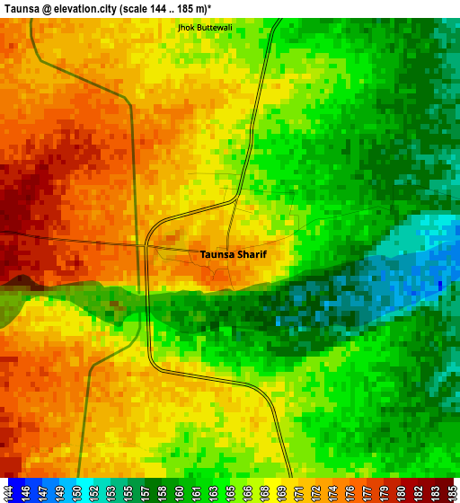
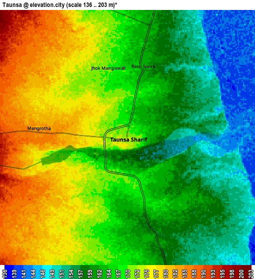
Below is the Elevation map of Taunsa, which displays elevation range with different colors. Scale of the first map is from 144 to 185 m (472 to 607 ft) with average elevation of 166.6 meters (=547 ft) [note 1]
These maps also provides idea of topography and contour of this city, they are displayed at different zoom levels. More info about maps, scale and edge coordinates you can find below images.
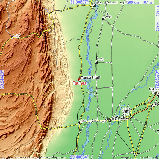
| \ | Map #1 | Map #2 | Topo.Map |
| Scale [m] | 144..185 m | 136..203 m | × |
| Scale [ft] | 472..607 ft | 446..666 ft | × |
| Average | 166.6 m = 547 ft | 166.3 m = 546 ft | × |
| Width | 8.4 km = 5.2 mi | 16.81 km = 10.4 mi | 268.9 km = 167.1 mi |
| Height | 8.4 km = 5.2 mi | 16.81 km = 10.4 mi | 268.9 km = 167.1 mi |
| ↑Max Latitude | 30.741358° | 30.779121° | 31.90507° |
| Latitude at center | 30.70358° | 30.70358° | 30.70358° |
| ↓Min Latitude | 30.665788° | 30.62798° | 29.48694° |
| ← Min Longitude | 70.606595° | 70.562649° | 69.24429° |
| Longitude center | 70.65054° | 70.65054° | 70.65054° |
| →Max Longitude | 70.694485° | 70.738431° | 72.05679° |
Nearby cities:
Cities around Taunsa sort by population:
• Dera Ghazi Khan elevation 122 m
73.1 km,  180°
180°
• Muzaffargarh 120 m
87.4 km,  143°
143°
• Kot Addu 136 m
40 km,  130°
130°
• Layyah 151 m
39.7 km,  43°
43°
• Karor 157 m
64.7 km,  26°
26°
• Chak Two Hundred Forty-nine Thal Development Authority 156 m
74.7 km,  45°
45°
• Daira Din Panah 139 m
31.2 km,  118°
118°
• Kot Sultan 145 m
27.9 km,  73°
73°
• Basti Dosa 142 m
22.8 km, 65°
• Bakhri Ahmad Khan 141 m
18.3 km,  78°
78°
• Moza Shahwala 144 m
22.1 km,  59°
59°
• Musa Khel Bazar 1349 m
81 km,  282°
282°
Multilingual:
 En español:
Taunsa elevación 175 m.
 En France:
Taunsa élévation 175 m.


Sources and notes:
- [note 1] Map square and city borders are not equal. Map elevation data is calculated only from area inside that square.
- [src 1] Elevation data from geonames database provided with same terms of usage.
- [src 2] The elevation map of Taunsa is generated using elevation data from NASA's 3 arcsec (90m) resolution SRTM data.
- [src 3] Base (background) map © OpenStreetMap contributors tiles are generated by Geofabrik and OpenTopoMap.
Copyright & License:
This Taunsa Elevation Map is licensed under CC BY-SA. You may reuse any part from this page, if you give a proper credit by linking to this URL:
 More info on terms of use page.