Dunyapur elevation
Dunyapur (Punjab), Pakistan elevation is 122 meters and Dunyapur elevation in feet is 400 ft above sea level [src 1]. Dunyapur is a populated place (feature code) with elevation that is 224 meters (735 ft) smaller than average city elevation in Pakistan.
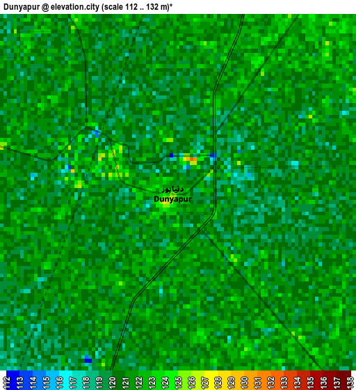
Below is the Elevation map of Dunyapur, which displays elevation range with different colors. Scale of the first map is from 112 to 132 m (367 to 433 ft) with average elevation of 120.5 meters (=395 ft) [note 1]
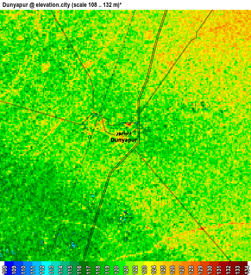
These maps also provides idea of topography and contour of this city, they are displayed at different zoom levels. More info about maps, scale and edge coordinates you can find below images.
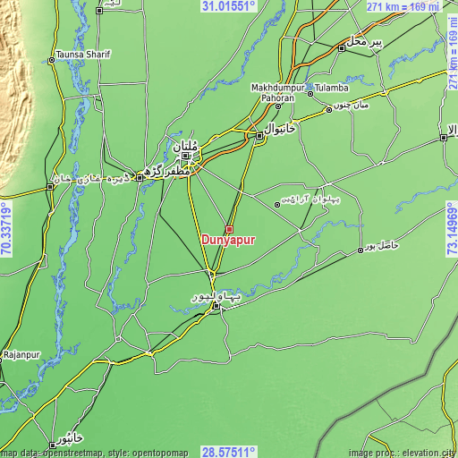
| \ | Map #1 | Map #2 | Topo.Map |
| Scale [m] | 112..132 m | 108..132 m | × |
| Scale [ft] | 367..433 ft | 354..433 ft | × |
| Average | 120.5 m = 395 ft | 120.6 m = 396 ft | × |
| Width | 8.48 km = 5.3 mi | 16.96 km = 10.5 mi | 271.3 km = 168.6 mi |
| Height | 8.48 km = 5.3 mi | 16.96 km = 10.5 mi | 271.4 km = 168.6 mi |
| ↑Max Latitude | 29.840876° | 29.878987° | 31.01551° |
| Latitude at center | 29.80275° | 29.80275° | 29.80275° |
| ↓Min Latitude | 29.76461° | 29.726455° | 28.57511° |
| ← Min Longitude | 71.699495° | 71.655549° | 70.33719° |
| Longitude center | 71.74344° | 71.74344° | 71.74344° |
| →Max Longitude | 71.787385° | 71.831331° | 73.14969° |
Nearby cities:
Cities around Dunyapur sort by population:
• Multan elevation 126 m
50.7 km,  329°
329°
• Bahawalpur 121 m
45.5 km,  188°
188°
• Lodhran 116 m
31.8 km,  199°
199°
• Kahror Pakka 132 m
25.8 km,  140°
140°
• Shujaabad 123 m
44.3 km,  281°
281°
• Mailsi 133 m
41.5 km,  90°
90°
• Jalalpur Pirwala 109 m
60.3 km,  236°
236°
• Khairpur Tamewah 133 m
53.7 km,  117°
117°
• Qadirpur Ran 131 m
54.8 km,  352°
352°
• Khangarh 120 m
57.6 km, 282°
• Dhanot 120 m
24.8 km,  178°
178°
• Khanewal 138 m
58.4 km,  18°
18°
Multilingual:
 En español:
Dunyapur elevación 122 m.
 En France:
Dunyapur élévation 122 m.
 Auf Deutsch:
Dunyapur höhe über dem Meeresspiegel ist 122 m.

Sources and notes:
- [note 1] Map square and city borders are not equal. Map elevation data is calculated only from area inside that square.
- [src 1] Elevation data from geonames database provided with same terms of usage.
- [src 2] The elevation map of Dunyapur is generated using elevation data from NASA's 3 arcsec (90m) resolution SRTM data.
- [src 3] Base (background) map © OpenStreetMap contributors tiles are generated by Geofabrik and OpenTopoMap.
Copyright & License:
This Dunyapur Elevation Map is licensed under CC BY-SA. You may reuse any part from this page, if you give a proper credit by linking to this URL:
 More info on terms of use page.