Multan elevation
Multan (Punjab), Pakistan elevation is 126 meters and Multan elevation in feet is 413 ft above sea level [src 1]. Multan is a seat of a second-order administrative division (feature code) with elevation that is 220 meters (722 ft) smaller than average city elevation in Pakistan.
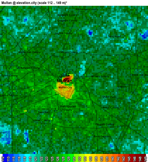
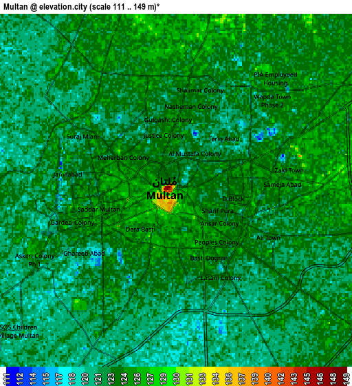
Below is the Elevation map of Multan, which displays elevation range with different colors. Scale of the first map is from 112 to 149 m (367 to 489 ft) with average elevation of 123.8 meters (=406 ft) [note 1]
These maps also provides idea of topography and contour of this city, they are displayed at different zoom levels. More info about maps, scale and edge coordinates you can find below images.
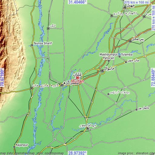
| \ | Map #1 | Map #2 | Topo.Map |
| Scale [m] | 112..149 m | 111..149 m | × |
| Scale [ft] | 367..489 ft | 364..489 ft | × |
| Average | 123.8 m = 406 ft | 122.9 m = 403 ft | × |
| Width | 8.45 km = 5.3 mi | 16.89 km = 10.5 mi | 270.3 km = 168 mi |
| Height | 8.45 km = 5.3 mi | 16.89 km = 10.5 mi | 270.3 km = 168 mi |
| ↑Max Latitude | 30.234765° | 30.272725° | 31.40466° |
| Latitude at center | 30.19679° | 30.19679° | 30.19679° |
| ↓Min Latitude | 30.158801° | 30.120797° | 28.97392° |
| ← Min Longitude | 71.434295° | 71.390349° | 70.07199° |
| Longitude center | 71.47824° | 71.47824° | 71.47824° |
| →Max Longitude | 71.522185° | 71.566131° | 72.88449° |
Nearby cities:
Cities around Multan sort by population:
• Muzaffargarh elevation 120 m
30.6 km,  243°
243°
• Kot Addu 136 m
57.7 km,  301°
301°
• Shujaabad 123 m
39.4 km,  206°
206°
• Kabirwala 138 m
43.6 km,  57°
57°
• Dunyapur 122 m
50.7 km,  149°
149°
• Ahmadpur Sial 133 m
59.2 km,  25°
25°
• Qadirpur Ran 131 m
21.4 km, 60°
• Khangarh 120 m
43.8 km,  224°
224°
• Dhanot 120 m
73.5 km,  158°
158°
• Sarai Sidhu 143 m
64.7 km,  46°
46°
• Daira Din Panah 139 m
66.5 km,  308°
308°
• Khanewal 138 m
45.1 km,  75°
75°
Multilingual:
 En español:
Multan elevación 126 m.
 En France:
Multan élévation 126 m.


Sources and notes:
- [note 1] Map square and city borders are not equal. Map elevation data is calculated only from area inside that square.
- [src 1] Elevation data from geonames database provided with same terms of usage.
- [src 2] The elevation map of Multan is generated using elevation data from NASA's 3 arcsec (90m) resolution SRTM data.
- [src 3] Base (background) map © OpenStreetMap contributors tiles are generated by Geofabrik and OpenTopoMap.
Copyright & License:
This Multan Elevation Map is licensed under CC BY-SA. You may reuse any part from this page, if you give a proper credit by linking to this URL:
 More info on terms of use page.