Gilgit elevation
Gilgit (Gilgit-Baltistan), Pakistan elevation is 1467 meters and Gilgit elevation in feet is 4813 ft above sea level [src 1]. Gilgit is a seat of a first-order administrative division (feature code) with elevation that is 1121 meters (3678 ft) bigger than average city elevation in Pakistan.
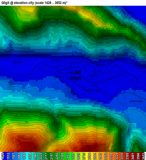
Below is the Elevation map of Gilgit, which displays elevation range with different colors. Scale of the first map is from 1426 to 3652 m (4678 to 11982 ft) with average elevation of 2002.4 meters (=6570 ft) [note 1]
These maps also provides idea of topography and contour of this city, they are displayed at different zoom levels. More info about maps, scale and edge coordinates you can find below images.
| \ | Map #1 | Map #2 | Topo.Map |
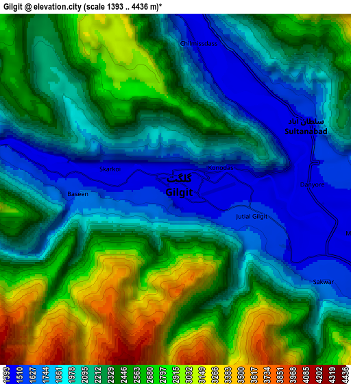
| Scale [m] | 1426..3652 m | 1393..4436 m | × |
| Scale [ft] | 4678..11982 ft | 4570..14554 ft | × |
| Average | 2002.4 m = 6570 ft | 2302.3 m = 7553 ft | × |
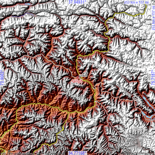
| Width | 7.91 km = 4.9 mi | 15.83 km = 9.8 mi | 253.2 km = 157.3 mi |
| Height | 7.91 km = 4.9 mi | 15.83 km = 9.8 mi | 253.2 km = 157.3 mi |
| ↑Max Latitude | 35.954271° | 35.989836° | 37.04931° |
| Latitude at center | 35.91869° | 35.91869° | 35.91869° |
| ↓Min Latitude | 35.883093° | 35.84748° | 34.77168° |
| ← Min Longitude | 74.268505° | 74.224559° | 72.9062° |
| Longitude center | 74.31245° | 74.31245° | 74.31245° |
| →Max Longitude | 74.356395° | 74.400341° | 75.7187° |
Nearby cities:
Cities around Gilgit sort by population:
• Muzaffarābād elevation 739 m
188.4 km,  203°
203°
• Battagram 1031 m
180.9 km,  220°
220°
• Shingli Bala 1041 m
183.1 km, 221°
• Skardu 2241 m
138 km,  120°
120°
• Barishal 2732 m
56.5 km,  37°
37°
• Alpurai 1451 m
188.4 km,  233°
233°
• Athmuqam 1386 m
154.4 km,  194°
194°
• Dasu 2552 m
115.7 km, 232°
• Eidgah 2372 m
80.3 km,  142°
142°
• Chilas 1279 m
59.3 km, 198°
• Gakuch 1892 m
57.1 km,  300°
300°
• Aliabad 2217 m
51 km,  32°
32°
Multilingual:
 En español:
Gilgit elevación 1467 m.
 En France:
Gilgit élévation 1467 m.


Sources and notes:
- [note 1] Map square and city borders are not equal. Map elevation data is calculated only from area inside that square.
- [src 1] Elevation data from geonames database provided with same terms of usage.
- [src 2] The elevation map of Gilgit is generated using elevation data from NASA's 3 arcsec (90m) resolution SRTM data.
- [src 3] Base (background) map © OpenStreetMap contributors tiles are generated by Geofabrik and OpenTopoMap.
Copyright & License:
This Gilgit Elevation Map is licensed under CC BY-SA. You may reuse any part from this page, if you give a proper credit by linking to this URL:
 More info on terms of use page.