Muzaffarābād elevation
Muzaffarābād (Azad Kashmir), Pakistan elevation is 739 meters and Muzaffarābād elevation in feet is 2425 ft above sea level [src 1]. Muzaffarābād is a seat of a first-order administrative division (feature code) with elevation that is 393 meters (1289 ft) bigger than average city elevation in Pakistan.
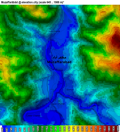
Below is the Elevation map of Muzaffarābād, which displays elevation range with different colors. Scale of the first map is from 645 to 1988 m (2116 to 6522 ft) with average elevation of 1010.5 meters (=3315 ft) [note 1]
These maps also provides idea of topography and contour of this city, they are displayed at different zoom levels. More info about maps, scale and edge coordinates you can find below images.
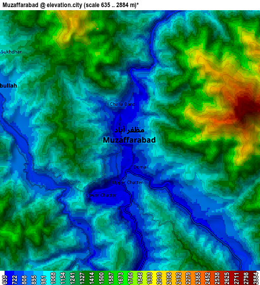
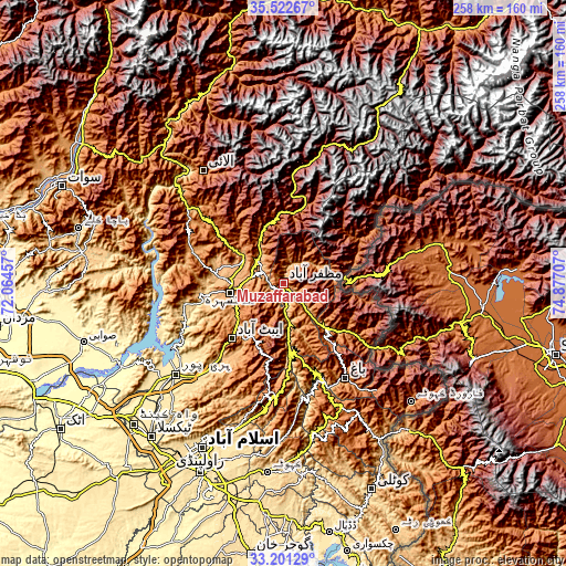
| \ | Map #1 | Map #2 | Topo.Map |
| Scale [m] | 645..1988 m | 635..2884 m | × |
| Scale [ft] | 2116..6522 ft | 2083..9462 ft | × |
| Average | 1010.5 m = 3315 ft | 1213.3 m = 3981 ft | × |
| Width | 8.07 km = 5 mi | 16.13 km = 10 mi | 258.1 km = 160.4 mi |
| Height | 8.07 km = 5 mi | 16.13 km = 10 mi | 258.1 km = 160.4 mi |
| ↑Max Latitude | 34.406285° | 34.442534° | 35.52267° |
| Latitude at center | 34.37002° | 34.37002° | 34.37002° |
| ↓Min Latitude | 34.333739° | 34.297443° | 33.20129° |
| ← Min Longitude | 73.426875° | 73.382929° | 72.06457° |
| Longitude center | 73.47082° | 73.47082° | 73.47082° |
| →Max Longitude | 73.514765° | 73.558711° | 74.87707° |
Nearby cities:
Cities around Muzaffarābād sort by population:
• Battagram elevation 1031 m
53.4 km,  309°
309°
• Abbottabad 1241 m
34.4 km,  223°
223°
• Mansehra 1079 m
25.5 km,  260°
260°
• Rawala Kot 1640 m
62.9 km,  154°
154°
• Havelian 863 m
45.3 km, 219°
• Murree 2098 m
51.9 km,  188°
188°
• Baffa 923 m
23.9 km,  288°
288°
• Shingli Bala 1041 m
56.2 km, 307°
• Amirabad 1297 m
40.4 km,  239°
239°
• Bagh 1100 m
51.6 km, 147°
• Athmuqam 1386 m
45.1 km,  60°
60°
• Hattian Bala 1006 m
33.5 km,  131°
131°
Multilingual:
 En español:
Muzaffarābād elevación 739 m.
 En France:
Muzaffarabad élévation 739 m.
 Auf Deutsch:
Muzaffarabad höhe über dem Meeresspiegel ist 739 m.

Sources and notes:
- [note 1] Map square and city borders are not equal. Map elevation data is calculated only from area inside that square.
- [src 1] Elevation data from geonames database provided with same terms of usage.
- [src 2] The elevation map of Muzaffarābād is generated using elevation data from NASA's 3 arcsec (90m) resolution SRTM data.
- [src 3] Base (background) map © OpenStreetMap contributors tiles are generated by Geofabrik and OpenTopoMap.
Copyright & License:
This Muzaffarābād Elevation Map is licensed under CC BY-SA. You may reuse any part from this page, if you give a proper credit by linking to this URL:
 More info on terms of use page.